



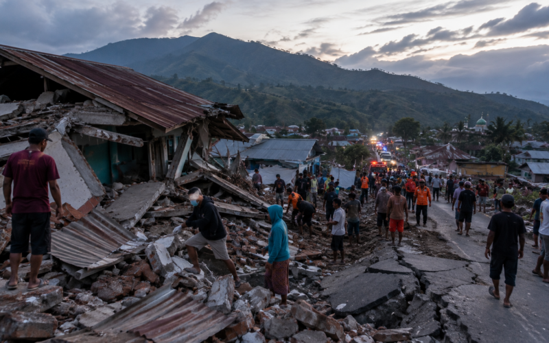
Indonesia was struck by a second powerful earthquake on August 15 as authorities raised the death toll from the devastating magnitude 7.7 Flores earthquake to 47 and warned that rescue teams had still not fully reached some of the communities closest to the epicentre.
The second earthquake, measuring magnitude 6.4 according to Indonesia’s Meteorology, Climatology and Geophysics Agency, or BMKG, struck Simalungun Regency in North Sumatra at 5:54 p.m. local western Indonesian time. Its epicentre was on land about 11 kilometres southeast of Simalungun at a depth of approximately 163 kilometres. The deep earthquake was strongly felt in Simalungun, Medan, Pakpak Bharat and Central Tapanuli but did not trigger a tsunami warning, and there were no immediate reports of major damage or casualties.
The North Sumatra event occurred while a much larger emergency was still unfolding around Flores in East Nusa Tenggara. Indonesia’s National Disaster Mitigation Agency, BNPB, said at 6:48 p.m. on August 15 that 47 people had been confirmed dead following the magnitude 7.7 earthquake that struck north of Flores before dawn. Twenty-four fatalities were recorded in Manggarai, 17 in East Manggarai, three in Sikka and one each in West Manggarai, Ngada and Ende.
The disaster is now substantially more serious than the picture that emerged during the first hours after the earthquake, when deaths had not yet been confirmed and the greatest concern centred on a possible tsunami. Rescue operations have since uncovered collapsed homes and public buildings, landslides have blocked roads, communications have failed in some locations and hundreds of aftershocks continue to shake communities already reluctant to return indoors.
BMKG said 235 aftershocks had been recorded by 2 p.m. on August 15, ranging from magnitude 2.5 to magnitude 6.2. The agency said the sequence had not yet shown a significant decline and estimated that the natural decay of seismic activity could take roughly two to three weeks.
How high has the death toll risen after Indonesia’s magnitude 7.7 Flores earthquake?
BNPB’s latest official update places the confirmed death toll at 47, making the August 15 earthquake one of Indonesia’s most serious seismic disasters of 2026. The agency said Manggarai suffered the largest confirmed loss of life with 24 deaths, followed by East Manggarai with 17. Sikka recorded three deaths, while West Manggarai, Ngada and Ende each recorded one.
Reuters said rescue teams had not yet fully accessed Nagekeo, the area closest to the epicentre, because landslides had blocked roads and mobile communications were disrupted. Attempts to enter by road were unsuccessful during the initial response, while another rescue team was trying to reach the affected area by ferry.
That access problem is one reason the casualty count remains capable of changing. The number of confirmed deaths reflects communities that authorities have been able to assess rather than necessarily the complete impact across the earthquake zone. Associated Press reported that some remote villages had been buried or isolated by landslides and that rescuers faced shortages of heavy equipment in areas where damaged roads were slowing access.
In Maumere, rescuers earlier reported recovering 20 bodies while searching a partially collapsed port building, with additional people injured and at least two trapped beneath debris during the initial response. The increasingly widespread reports of damage demonstrate how quickly the event moved from a tsunami emergency into a major land-based rescue operation.

How much damage has been confirmed across Flores as rescue teams reach more communities?
BNPB said preliminary assessments had identified 157 homes with severe damage, another 41 with moderate damage and 148 with lighter damage by late afternoon on August 15. Public infrastructure was also heavily affected, with damage reported at 87 educational facilities, 18 healthcare facilities, five places of worship and six government offices.
Reuters reported that the earthquake produced strong shaking across East Nusa Tenggara, West Nusa Tenggara and parts of South Sulawesi, with residents in several locations describing tremors lasting around a minute. Video verified by Reuters showed part of a building at Maumere port collapsing into dust and rubble as people fled.
Around 2,000 residents evacuated in Nagekeo alone, according to BNPB, while temporary evacuation locations were also established in parts of the Selayar Islands in South Sulawesi. Power outages, traffic congestion and communication disruptions complicated assessments in some of the hardest-hit districts.
The Indonesian government has begun moving significant emergency supplies towards the region. BNPB said 50,000 packages weighing approximately 275 tonnes were being prepared for dispatch from Jakarta, with 10,500 packages originating from President Prabowo Subianto having reached the Halim Perdanakusuma Air Force base by the agency’s latest update. Additional food and non-food supplies were being moved through an emergency logistics facility in East Flores.
Why did the Flores tsunami become more significant than early reports suggested?
Initial reports said tsunami waves recorded following the earthquake remained below one metre at several locations. More complete BMKG observations later showed that the highest measured wave reached 1.61 metres at Reo Manggarai and East Manggarai.
BMKG also recorded a 0.94-metre wave at Maurole in Ende, while water-level increases exceeding 0.5 metres were observed at Bulukumba and Sape in Bima. The agency ended the tsunami warning at 7:30 a.m. after tide gauges indicated that dangerous sea-level fluctuations had subsided.
The earthquake occurred beneath the Flores Sea at a shallow depth of approximately 15 kilometres and involved movement along the Flores Back Arc Thrust, according to BMKG. The thrust-fault mechanism is capable of producing vertical displacement that can generate tsunami waves when a sufficiently large rupture occurs beneath or near the sea.
BMKG had initially placed several coastal areas under its Siaga tsunami category, modelling possible waves between 0.5 and 3 metres. The eventual 1.61-metre maximum therefore remained within the agency’s original risk range even though the event stopped well short of the most severe scenario authorities feared immediately after the magnitude 7.7 rupture.
Why are 235 aftershocks creating a new danger even after the tsunami warning ended?
The tsunami threat has passed, but BMKG’s aftershock data show that the seismic emergency has not.
By 2 p.m. on August 15, BMKG had recorded 235 aftershocks north of Flores with magnitudes ranging from 2.5 to 6.2. More importantly, the agency said the frequency of aftershocks had not yet shown a significant declining trend.
BMKG chief Teuku Faisal Fathani said historical patterns from other damaging Indonesian earthquakes suggest that fault stabilisation could require approximately two to three weeks. That does not mean strong earthquakes will continue continuously for that entire period, but it does mean authorities expect an extended aftershock sequence rather than an immediate return to normal seismic conditions.
That matters because an aftershock does not need to approach magnitude 7.7 to cause additional casualties. Buildings weakened by the main earthquake can fail under substantially smaller shaking, while slopes destabilised during the first event can generate additional landslides.
BMKG has consequently advised residents to stay away from buildings showing structural cracks or other damage and to rely on official earthquake information rather than rumours. The continuing magnitude 6-range aftershocks provide a practical reason many evacuated residents remain unwilling to return home.
What caused the magnitude 7.7 Flores earthquake and why was the damage so extensive?
BMKG identified the source as the Flores Back Arc Thrust, a major reverse-fault system running along the northern side of the island chain. Compression within the tectonically complex region causes sections of the Earth’s crust to move over one another, periodically releasing enormous amounts of accumulated energy.
The August 15 earthquake was particularly dangerous because it occurred at only about 15 kilometres depth. Shallow earthquakes generally allow more of their energy to reach the surface with strong shaking close to the source than otherwise comparable earthquakes originating much deeper underground.
BMKG’s intensity observations reached VII on the Modified Mercalli scale around Aesesa in Nagekeo, Riung in Ngada, Kota Ambai and areas assessed around Manggarai and Ruteng. Intensity VI was measured around Wolowae and Bajawa, while intensity V shaking affected several surrounding areas.
The agency is now deploying specialist teams to carry out microzonation and broader damage surveys across Ngada, Nagekeo and other affected areas. Those studies are intended to identify how different soil and geological conditions amplified shaking and to provide technical guidance for rebuilding or strengthening damaged structures.
Is the magnitude 6.4 North Sumatra earthquake connected to the Flores disaster?
There is currently no official indication that the two earthquakes are directly connected, and geographical proximity on a map of Indonesia should not be interpreted as evidence that one caused the other.
The magnitude 6.4 Simalungun earthquake occurred thousands of kilometres from Flores and was also very different in depth. BNPB, citing BMKG, placed the North Sumatra earthquake at approximately 163 kilometres beneath the surface, compared with just 15 kilometres for the Flores mainshock.
The Simalungun earthquake occurred at 5:54 p.m. western Indonesian time with an epicentre on land. It was felt strongly for around 30 seconds in Simalungun, Medan and Pakpak Bharat and for around 10 seconds in Central Tapanuli. BNPB said emergency agencies were assessing whether the shaking caused any casualties or structural damage.
Reuters later reported no immediate indication of damage or a tsunami threat. BMKG described it as a deep earthquake, a characteristic that generally reduces the concentration of destructive surface shaking near the epicentre compared with a shallow event of the same magnitude.
The timing nevertheless creates an unusually difficult day for Indonesia’s disaster-response agencies. While national resources are moving towards Flores, authorities in North Sumatra must independently inspect buildings and monitor communities affected by a second major earthquake.
Why does the 1992 Flores earthquake remain an important warning for the current disaster?
The same broad fault system has produced catastrophic earthquakes before.
BMKG highlighted a destructive earthquake in 1992 associated with the Flores Back Arc Thrust. The agency describes that historical event as magnitude 7.8 at a depth of approximately 28 kilometres, while Reuters notes the devastation produced by the 1992 Flores earthquake and tsunami.
The comparison is particularly notable because the 2026 earthquake occurred at an even shallower 15-kilometre depth. BMKG said this helped produce relatively severe physical effects on infrastructure and contributed to tsunami generation observable as far away as coastal areas of South and Southeast Sulawesi.
Indonesia has made substantial improvements to tsunami monitoring and warning since previous disasters. BMKG said its warning for the August 15 event was issued only two minutes and 16 seconds after the mainshock and updated again once more precise earthquake parameters became available.
That rapid warning appears to have helped trigger evacuations before authorities knew exactly how high the waves would become. The comparatively limited tsunami toll so far does not diminish the seriousness of a 1.61-metre wave, but it indicates that the most catastrophic coastal scenario did not materialise.
What are the key takeaways from Indonesia’s two major earthquakes on August 15?
- Indonesia’s confirmed death toll from the magnitude 7.7 Flores earthquake has risen to 47, with 24 deaths in Manggarai, 17 in East Manggarai, three in Sikka and one each in West Manggarai, Ngada and Ende.
- Rescue teams have struggled to reach some communities, including Nagekeo near the epicentre, because landslides have blocked roads and mobile communications have been disrupted.
- BNPB has recorded 157 severely damaged homes, 41 moderately damaged homes and 148 with lighter damage, along with damage to 87 schools, 18 healthcare facilities, five places of worship and six government offices.
- BMKG recorded 235 aftershocks by 2 p.m., ranging between magnitude 2.5 and 6.2, and said the sequence had not yet shown a significant decline. The agency estimates stabilisation could take two to three weeks.
- The Flores earthquake generated a confirmed tsunami reaching 1.61 metres at Reo Manggarai and East Manggarai, with a 0.94-metre wave at Maurole in Ende and waves above 0.5 metres at other monitoring locations.
- A separate magnitude 6.4 earthquake struck Simalungun in North Sumatra later on August 15 at a depth of approximately 163 kilometres. It was strongly felt in several areas but did not trigger a tsunami warning, and no immediate major damage was reported.
- There is no official evidence that the North Sumatra earthquake was caused by or directly connected with the Flores earthquake, and the events occurred in different regions with very different source depths.
- Indonesia is now simultaneously managing an expanding rescue operation in Flores, an extended aftershock sequence and damage assessments in North Sumatra, making August 15 one of the country’s most consequential seismic days of 2026.
Why the rise from no early fatalities to 47 deaths changes the Flores earthquake story completely
The first hours after the Flores earthquake suggested Indonesia might have narrowly avoided a major disaster. The magnitude was enormous and a tsunami warning forced evacuations, but early reports indicated relatively modest waves and no confirmed deaths. That picture has changed dramatically as rescue teams have reached damaged communities and authorities have gathered casualty reports from across Flores.
Forty-seven deaths, hundreds of damaged homes and widespread destruction of schools and healthcare facilities establish that the main source of devastation was not the tsunami alone. The shallow earthquake itself produced destructive ground motion across a broad part of Flores, collapsing buildings and triggering landslides capable of cutting isolated communities off from rescuers.
The tsunami also proved larger than the earliest observations suggested. BMKG’s confirmed 1.61-metre reading demonstrates that meaningful coastal inundation occurred even though the event did not approach the worst-case scenario modelled by the warning system.
What happens next depends heavily on access. Nagekeo lies close to the earthquake source, yet Reuters reported rescue teams had been unable to reach parts of the regency by road. As communications are restored and isolated communities are assessed, both casualty and damage numbers can still change.
The aftershock sequence presents the second major uncertainty. With 235 events already recorded and magnitudes reaching 6.2, residents are facing a prolonged period in which damaged structures and unstable slopes remain dangerous. BMKG’s estimate that seismic activity could require two to three weeks to settle means the emergency will not end simply because the first night has passed.
The magnitude 6.4 North Sumatra earthquake adds a striking but separate development. Nothing currently indicates that it forms part of the Flores sequence, and its much greater depth helps explain why authorities have not reported comparable damage. Yet the occurrence of another strong earthquake on the same day underlines the fundamental challenge Indonesia faces as an archipelago spanning multiple intensely active tectonic zones.
The immediate priority remains Flores. The tsunami warning has ended, but rescue operations, aftershocks and blocked access mean the disaster is still developing. The most important number is therefore no longer the earthquake’s magnitude of 7.7. It is the human toll, now at 47 and still provisional as rescuers work towards communities that have not yet been fully assessed.
Discover more from Business-News-Today.com
Subscribe to get the latest posts sent to your email.