




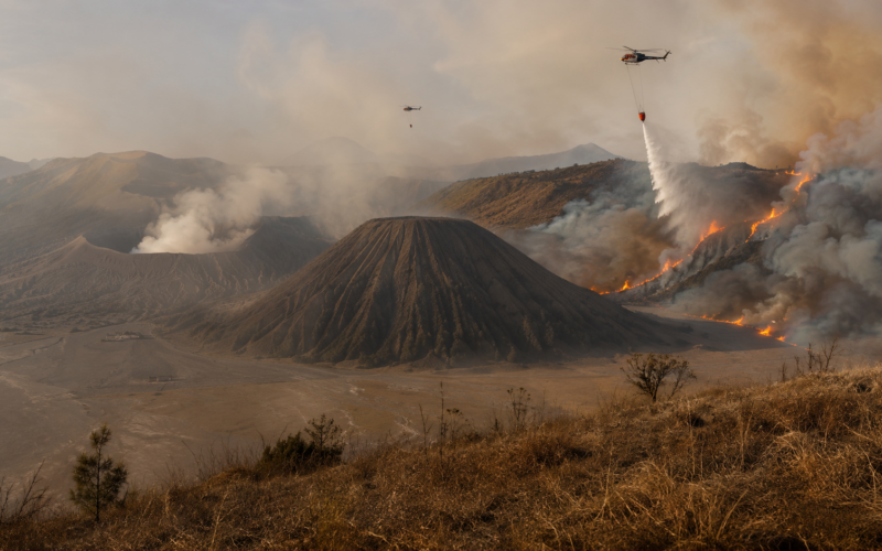
Indonesia has completely closed Mount Bromo to tourists after a wildfire racing across the slopes of the famous East Java volcano expanded to approximately 176 hectares, almost three times the area reported only days earlier.
The closure took effect on Saturday evening, August 8, and will remain in place for an undetermined period as authorities attempt to contain the blaze inside Bromo Tengger Semeru National Park. Visitors who have already purchased tickets will be allowed to reschedule their trips or request refunds, according to the park operator.
The fire has been burning since Monday and had affected around 60 hectares by Thursday. By August 9, the affected area had grown to approximately 176 hectares, or about 435 acres, demonstrating how quickly the blaze has expanded across the dry volcanic landscape. Authorities have not identified the cause, and no casualties have been reported at Mount Bromo.
East Java emergency authorities are using water-bombing helicopters and water-spraying drones to attack hotspots that cannot easily be reached by ground crews. Earlier in the response, two helicopters were deployed because steep slopes and strong winds were making conventional firefighting difficult, while officials also prepared weather-modification measures including cloud seeding.
The full closure turns the wildfire into a significant tourism disruption as well as an environmental emergency. Mount Bromo is one of Indonesia’s most recognisable volcanic destinations, famous for its enormous Tengger caldera, sunrise viewpoints and the distinctive “Sea of Sand” surrounding the active volcano.
Why has Indonesia completely closed Mount Bromo after initially restricting only parts of the tourist area?
Authorities initially attempted to manage the emergency through partial tourism restrictions while firefighting continued. That approach became increasingly difficult as the fire expanded across the caldera landscape and threatened to spread into areas used by visitors, tourism operators and emergency personnel.
By Saturday evening, the Bromo Tengger Semeru National Park operator decided that all tourist activity should stop. The park said the full closure was necessary to protect visitors, staff and communities around the affected area while firefighters worked in dangerous and unpredictable conditions.
The change from partial restrictions to complete closure illustrates how quickly wildfire conditions can deteriorate. A route or viewing area considered relatively safe during the morning can become exposed several hours later when wind pushes flames across dry grass and vegetation.
Mount Bromo presents additional difficulties because tourists normally enter from several directions through communities and roads surrounding the caldera. Keeping some access routes open while others are threatened can complicate evacuation and potentially interfere with emergency vehicles.
The indefinite nature of the closure is equally significant. Indonesian authorities have not announced a reopening date because that decision will depend on containment, weather conditions and whether hotspots continue burning underneath vegetation after visible flames have subsided.

How did the Mount Bromo wildfire expand from 60 hectares to around 176 hectares within days?
Dry vegetation, difficult terrain and strong winds appear to be the principal factors helping the blaze spread, although investigators have not determined what initially started the fire.
Indonesia’s National Disaster Management Agency said earlier in the week that several hotspots were located on steep slopes that ground firefighters could not easily reach. Strong winds were simultaneously capable of accelerating the flames and carrying burning material towards previously unaffected areas.
These conditions create a particularly difficult wildfire environment. Crews cannot simply drive firefighting vehicles towards every hotspot because much of the terrain around Mount Bromo is volcanic, steep or inaccessible by conventional roads.
Fire can therefore continue spreading across areas that personnel can observe but cannot safely approach. Aircraft become critical because they can drop water directly onto remote sections of the fire, while drones can reach smaller zones and provide firefighters with a clearer picture of changing conditions.
The expansion from roughly 60 hectares on Thursday to around 176 hectares by Sunday morning means the estimated burned area increased by almost three times within several days. Video released by the park operator showed flames spreading across mountain slopes overnight, reinforcing concerns that the fire remained active despite extensive suppression efforts.
Wind will remain one of the variables determining what happens next. Even when firefighters suppress the main fire front, stronger gusts can reignite smouldering areas or carry embers beyond containment lines.
How are helicopters, firefighting drones and cloud seeding being used against the Bromo wildfire?
Indonesia has increasingly turned to aerial firefighting because the landscape prevents ground teams from reaching every hotspot safely.
Two water-bombing helicopters were deployed during the earlier phase of the response. Aircraft can carry substantial quantities of water and release them over active fire zones, reducing temperatures and slowing the advance sufficiently for ground crews to strengthen containment lines.
East Java authorities are also using water-spraying drones. These smaller unmanned systems cannot replace helicopters in terms of water volume, but they can operate closer to difficult terrain and reach locations where sending firefighters would carry unnecessary risks.
Drones can additionally provide reconnaissance. Thermal and visual cameras help locate hotspots hidden by smoke or terrain, allowing crews to concentrate resources on areas most likely to reignite or expand.
Authorities have also prepared weather-modification operations such as cloud seeding. The approach attempts to encourage rainfall when suitable atmospheric conditions exist, providing additional moisture that can slow wildfire spread and assist firefighters.
Cloud seeding is not a guaranteed solution because it depends heavily on existing cloud conditions. It is better viewed as one additional tool supporting conventional firefighting rather than a substitute for aircraft, drones and ground crews.
The combined response demonstrates how wildfire management increasingly depends on technology when fires occur inside rugged protected landscapes.
Why is a wildfire at Mount Bromo particularly difficult to fight compared with fires on flatter terrain?
Mount Bromo sits inside the enormous Tengger volcanic caldera, producing a landscape very different from conventional forest or grassland firefighting environments.
The volcano rises to approximately 2,329 metres above sea level and is surrounded by steep slopes, volcanic ridges and the broad sandy caldera floor commonly known as the Sea of Sand. Access routes that work well for tourism do not necessarily allow heavy firefighting equipment to reach every burning area.
Steep slopes also influence how flames behave. Fire can move rapidly uphill because heat rising from the burning vegetation preheats material farther up the slope, allowing it to ignite more quickly.
Strong winds create another layer of uncertainty. They can alter the direction of flames and transport embers across distances that ground crews cannot easily defend.
Smoke may also reduce visibility for both firefighters and aircraft. Helicopters require sufficiently safe flying conditions, meaning severe smoke or turbulent winds can temporarily restrict aerial operations precisely when they are most needed.
The result is a fire in which containment cannot be judged purely by acreage. A relatively small burning area positioned on inaccessible slopes may require more resources than a much larger blaze on terrain that vehicles and personnel can approach safely.
How important is Mount Bromo to tourism in East Java and Indonesia’s wider travel economy?
Mount Bromo is among Indonesia’s best-known natural attractions and forms a central part of the tourism economy across several East Java districts.
Visitors frequently travel overnight from Malang, Surabaya and surrounding towns to reach high viewpoints before sunrise. Tours then descend into the Tengger caldera and cross the Sea of Sand towards the Bromo crater.
That travel pattern supports a wide ecosystem of businesses, including hotels, homestays, jeep operators, restaurants, guides, motorcycle transport providers and local souvenir sellers.
An indefinite shutdown therefore affects significantly more than ticket revenue collected by the national park.
Tour companies may have to cancel or rearrange itineraries, accommodation providers could experience reduced bookings and visitors travelling through East Java may redirect spending towards other destinations.
The timing during the northern hemisphere summer travel period adds to the potential disruption because August is an important month for international tourism.
The consequences will depend heavily on how long the closure lasts. A short shutdown lasting several days may primarily create logistical inconvenience. A closure extending for weeks could produce substantially greater revenue losses for communities that depend on Mount Bromo tourism.
The park’s decision to permit affected visitors to reschedule or seek refunds demonstrates that officials recognise the uncertainty surrounding reopening.
Could the Mount Bromo wildfire threaten nearby communities or agricultural areas?
No casualties have been reported from the Mount Bromo fire, and authorities have not announced large-scale residential evacuations connected with the blaze as of August 9.
Nevertheless, national park fires can become community emergencies if changing winds push flames beyond protected boundaries.
The Tengger highlands contain settlements and extensive agricultural activity. Local communities cultivate vegetables and other crops on fertile volcanic soils, meaning prolonged fire conditions can threaten both natural ecosystems and livelihoods.
Smoke creates an additional concern even when flames remain distant from homes. Thick smoke can worsen respiratory conditions, reduce road visibility and affect tourism activity across a much broader area than the actual fire perimeter.
Authorities will therefore be monitoring not only the main blaze but also the potential for embers to establish separate hotspots closer to farmland or populated areas.
Preventing the fire from reaching water sources is another important consideration. Previous firefighting operations in the wider Bromo region have included efforts specifically aimed at stopping fires from spreading towards agricultural land, communities and water resources.
Is the Mount Bromo fire connected to Indonesia’s wider wildfire and haze problem in August 2026?
Mount Bromo is not the only part of Indonesia experiencing wildfire activity.
Fires have also been reported across Sumatra and Borneo during the current dry period. The Associated Press reported that one person died after running out of oxygen while trying to escape smoke from a wildfire in Ketapang Regency in West Kalimantan.
Indonesia’s dry-season fires are closely watched throughout Southeast Asia because large fires on Sumatra and Borneo can generate transboundary haze affecting Singapore, Malaysia and other neighbouring areas.
The situation at Mount Bromo is geographically separate and does not by itself imply a major international haze event.
However, simultaneous fires across several Indonesian islands can increase regional air-quality concerns if dry conditions persist.
Vegetation fires can release enormous quantities of fine particulate matter capable of travelling long distances depending on atmospheric conditions and wind direction.
Indonesia has invested heavily in wildfire prevention and suppression following severe haze crises in previous years. Yet the country’s enormous geography, tropical forests, peatlands, agricultural areas and remote terrain make complete prevention extremely difficult.
The Bromo emergency highlights another dimension of the problem: even iconic protected landscapes and tourism destinations are vulnerable when vegetation becomes dry enough to burn rapidly.
What is known about the cause of the Mount Bromo wildfire and could human activity be responsible?
Authorities have not announced what caused the fire, and any claim assigning responsibility would currently be premature.
Wildfires can begin through natural causes such as lightning, but many vegetation fires worldwide are connected directly or indirectly with human activity. Potential causes can include discarded cigarettes, unattended campfires, agricultural burning, vehicle activity or deliberate ignition.
None of those possibilities has been established in the Mount Bromo case.
Investigators will likely examine where the first flames were recorded, whether visitors or agricultural activity occurred nearby and whether weather conditions provide evidence of a natural ignition.
The national park has dealt with damaging fires before, making prevention a sensitive subject among conservation authorities and tourism operators.
Determining the cause matters for more than assigning responsibility. If investigators identify a preventable human activity, authorities may introduce new tourism restrictions or enforcement measures after the park reopens.
If dry vegetation and extreme weather were the dominant factors, management attention may instead shift more heavily towards firebreaks, early detection and emergency suppression capability.
What are the key takeaways from Indonesia’s Mount Bromo wildfire and full tourism closure?
- Indonesia has closed all tourist access to Mount Bromo from the evening of August 8 for an indefinite period after the wildfire expanded significantly across Bromo Tengger Semeru National Park.
- The estimated burned area reached around 176 hectares, or roughly 435 acres, by August 9, up from approximately 60 hectares reported on Thursday, meaning the affected area has almost tripled within days.
- Authorities are deploying water-bombing helicopters and water-spraying drones because steep slopes make several hotspots difficult and potentially dangerous for ground firefighting teams to reach.
- Indonesia’s disaster agency has also prepared weather-modification operations including cloud seeding as an additional firefighting measure if suitable atmospheric conditions allow it.
- Strong winds are complicating containment by accelerating flames and potentially carrying burning material towards areas beyond the existing fire perimeter.
- Authorities have not determined the cause of the Mount Bromo wildfire, and no casualties have been reported from the blaze as of August 9.
- The indefinite closure could affect tourism businesses across East Java because Mount Bromo supports hotels, jeep tours, guides, restaurants and other businesses built around one of Indonesia’s most internationally recognised volcanic destinations.
- The Bromo emergency is occurring alongside wildfire activity elsewhere in Indonesia, including Sumatra and Borneo, raising broader concerns about dry-season fires and the potential for worsening regional haze if conditions remain dry.
Why the jump from 60 to 176 hectares makes the next 48 hours critical for Mount Bromo
The decision to close every tourist route suggests Indonesian authorities no longer regard the Mount Bromo wildfire as an incident that can safely coexist with normal visitor activity.
That is a sensible shift.
The fire has almost tripled in estimated size since Thursday, and its location on steep volcanic terrain gives wind and accessibility unusually large influence over containment. Firefighters may make considerable progress in one area while another inaccessible hotspot continues burning or sends embers across existing lines.
The deployment of helicopters, firefighting drones and possible cloud seeding shows that Indonesia is committing increasingly sophisticated resources to the operation.
The immediate objective will be preventing another major increase in the fire perimeter while protecting surrounding communities, tourism infrastructure and environmentally sensitive areas of the national park.
Weather will determine much of what happens next. Lower winds and increased humidity would give firefighters an opportunity to attack hotspots more aggressively. Stronger winds and continued dry conditions could undo containment work rapidly.
For the tourism industry, reopening should depend on fire stability rather than pressure to restore visitor access quickly. Mount Bromo’s popularity means thousands of people can enter the broader area during busy periods, and evacuating visitors after conditions deteriorate would create unnecessary risk.
The August 9 closure therefore represents more than the temporary loss of access to a famous sunrise destination.
It is a reminder that one of Indonesia’s most dramatic volcanic landscapes is simultaneously a fragile high-altitude ecosystem where tourism, local livelihoods and natural hazards coexist.
The most encouraging fact is that no casualties have been reported. The most concerning one is the speed at which the fire grew from around 60 hectares to 176 hectares.
Whether authorities can stop that acceleration will determine how quickly Mount Bromo can reopen and how serious the environmental and economic consequences ultimately become.
Discover more from Business-News-Today.com
Subscribe to get the latest posts sent to your email.