


A relentless storm system sweeping across the central United States has intensified into a crisis of unprecedented proportions, bringing life-threatening flash floods to communities already reeling from a deadly tornado outbreak. As of Friday, at least eight fatalities have been confirmed across Tennessee, Missouri, Indiana, and Kentucky, amid widespread destruction fueled by historic rainfall and a severe storm threat that shows no signs of relenting.
In Frankfort, Kentucky, the dangers turned personal and heartbreaking when 9-year-old Gabriel Andrews was swept away by raging floodwaters while walking to his school bus stop. Authorities later recovered his body half a mile from the site, despite the best efforts of first responders who searched for over two hours in increasingly hazardous conditions. His death underscored the dire risk facing communities trapped between catastrophic tornado aftermath and torrential rain.
The Mississippi Valley region — covering parts of Arkansas, Missouri, Tennessee, and Mississippi — is now in the midst of a rare level 4 out of 4 high-risk designation for flooding rains, a classification typically reserved for hurricane scenarios. With record-setting rainfall soaking the region for several consecutive days, forecasters are warning of “once-in-a-generation” flood potential that could exceed 12 inches in isolated pockets.
Which states are experiencing the worst impacts of the floods and tornadoes?
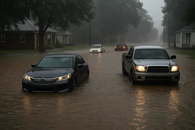
Kentucky, Missouri, and Tennessee have emerged as the epicenters of this multifaceted weather disaster. More than 260 flood warnings were in effect across 15 states as of Friday evening, with around 4 million people under flash flood warnings spanning from Texas to Kentucky. On the ground, the situation remains volatile and fluid, as rising water levels continue to block roads, overwhelm sanitation infrastructure, and spark emergency evacuations.
In Van Buren, Missouri, emergency crews conducted at least 15 water rescues after more than three inches of rain triggered rapid flash flooding. In Louisville, Kentucky, local officials urged residents to reduce water usage for household appliances such as dishwashers and washing machines, as the city’s sewer systems neared capacity.
Meanwhile, in northeastern Texas and Arkansas, rotating supercells triggered tornado warnings and sightings on Friday afternoon. Wood County emergency authorities reported at least one injury and significant home damage after multiple trees toppled during a suspected tornado touchdown. The destruction adds to the cumulative toll of storms that have devastated parts of the region since Wednesday.
Selmer, Tennessee, about 90 miles east of Memphis, was among the hardest-hit towns during the recent tornado outbreak. Residents described sheltering in laundry rooms as powerful winds ripped through their new apartment complex. Though some units survived, entire sections of the front were demolished. Governor Bill Lee urged Tennesseans not to let their guard down, warning that the storm system remains highly dangerous and unpredictable.
What role is climate change playing in intensifying these events?
Meteorologists and climate scientists have increasingly pointed to global warming as a major factor amplifying the severity and frequency of extreme weather events. A recent analysis found that hourly rainfall rates have risen in nearly 90% of large U.S. cities since 1970. Warmer air holds more moisture, which leads to heavier downpours during storms. The current flooding event is being described in statistical terms as a 1-in-25, 1-in-100, and even 1-in-1000-year rainfall occurrence, illustrating its exceptional rarity.
The National Oceanic and Atmospheric Administration (NOAA) has warned that as greenhouse gas emissions continue to warm the atmosphere, events like this are likely to become more common and more destructive. This compounds the risks in flood-prone areas, especially those lacking robust drainage infrastructure or where urban development has reduced natural water absorption.
The flash flood emergency affecting the Ohio Valley and Lower Mississippi Valley may soon be among the most devastating inland flooding events in recent U.S. history if rainfall continues at forecasted rates. The Weather Prediction Center has reiterated that a “life-threatening, catastrophic, and potentially historic” flash flood event remains underway, particularly affecting far northeastern Texas, Arkansas, Missouri, and Kentucky.
How are emergency agencies responding to the dual threat of floods and tornadoes?
Federal, state, and local agencies have rapidly mobilized to respond to the escalating crisis. Water rescue teams have been dispatched across flood zones, and emergency supplies including food, blankets, and clean water are being distributed in anticipation of worsening conditions. In Nashville, first responders carried out at least a dozen water rescues, including a dramatic extraction of a driver from a flooded vehicle near Trevecca Nazarene University.
In Missouri, the Army Corps of Engineers reported it had filled around 1,500 sandbags to reinforce a levee near Poplar Bluff, where the Black River is forecast to reach “major flooding” status by the weekend. Urban search and rescue teams have also been deployed in the region to bolster local response capabilities.
Tornado sirens in Nashville were rendered inoperable after sounding so frequently that their batteries drained, further complicating efforts to alert residents. Officials are urging the public to use multiple sources for weather alerts — including mobile apps, radios, and local news — as storm activity remains active across the region.
In the small city of Pilot Grove, Missouri, residents like Justin Gerke returned home to find their roofs torn off and vehicles destroyed. The city of Nevada, Missouri, also saw severe damage, particularly at Nevada Oaks, a repurposed motel now housing students at the Missouri Welding Institute. Although no injuries were reported, the tornado shattered windows, crushed cars, and left the facility inoperable.
What disruptions are expected in the coming days?
The ongoing storm system threatens not just human safety, but regional infrastructure and economic activity. Major cargo hubs in Louisville, Kentucky, and Memphis, Tennessee — both key logistical centers for nationwide shipping — are facing potential delays due to flooding and severe storm activity. These disruptions may ripple across supply chains, especially for time-sensitive freight.
Several school districts across Tennessee and Kentucky announced closures on Friday to ensure student safety, including Allen County Schools and Davidson Academy. Power outages also remain widespread, with over 2,200 customers affected in Tennessee alone as of Friday evening.
Governor Andy Beshear of Kentucky declared a state of emergency for the state’s western counties, noting that many of the affected areas are unaccustomed to such levels of rainfall. More than 300 roads, including 109 state highways, were closed due to flooding.
This follows a recent pattern of extreme weather in Kentucky. In February, a deadly winter storm brought similar devastation, and in 2021, large-scale flash flooding caused long-term damage and multiple fatalities. The current event has again placed stress on an already-vulnerable emergency response infrastructure.
What’s next for the region as storms continue?
With multiple tornadoes already confirmed across eight states since Wednesday, including at least three of EF3 strength in Missouri, Arkansas, and Tennessee, the danger remains acute. The Storm Prediction Center has issued a level 4 of 5 risk for severe thunderstorms in northeastern Texas, Arkansas, and southern Missouri — a corridor where more tornadoes, large hail, and destructive winds could develop through the weekend.
The National Weather Service’s damage survey teams have already issued preliminary ratings for 31 tornadoes, but hazardous conditions have delayed further assessments. Some areas could see the total number of confirmed tornadoes rise significantly in the coming days as access improves.
As the region faces overlapping threats of tornadoes, severe storms, and historic flooding, officials and residents alike are bracing for prolonged recovery efforts. The combination of deadly winds, structural devastation, and prolonged inundation presents a formidable challenge to already-stressed emergency systems.
In many parts of the central US, the current crisis reflects not just a weather emergency, but a growing reality of climate-driven volatility. With lives lost, infrastructure tested, and communities submerged, the unfolding disaster highlights the urgent need for climate resilience, emergency preparedness, and long-term investment in flood mitigation strategies — before once-in-a-generation events become commonplace.
Discover more from Business-News-Today.com
Subscribe to get the latest posts sent to your email.