

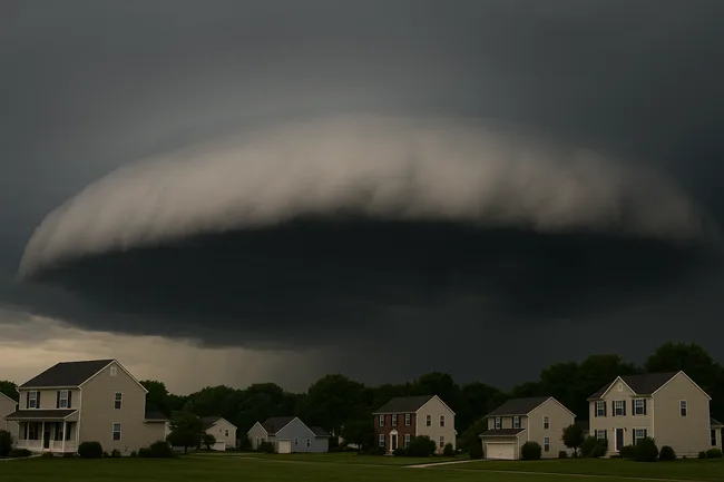
A dramatic shelf cloud moving across Bowie, Maryland on Wednesday sparked widespread alarm, as residents shared viral videos comparing the formation to apocalyptic scenes. The ominous, tube-like structure appeared just hours into a severe weather day for the D.C.–Maryland–Virginia region, prompting warnings for thunderstorms, flash flooding, wind damage and possible tornadoes.
Authorities confirmed the eerie cloud was a shelf cloud—a natural atmospheric phenomenon formed when cold air from a storm front pushes into warm, moist air. As the cold air advances, it lifts the warmer air layer above, condensing into the characteristic rolling “shelf” structure. Although spectacular in appearance, meteorologists emphasized that a shelf cloud does not pose a tornado risk, serving instead as a visual sign of a storm’s leading edge. The National Weather Service reiterated that shelf clouds alone are not dangerous.

What did the latest storm reports reveal about damage and rain intensity across the D.C. metropolitan area?
Updated meteorological data shows the storm system unleashed intense rainfall and gusty winds between 5 p.m. and 8 p.m. EDT on July 9. Reagan National Airport recorded 1.16 inches of rain in just 20 minutes, along with wind gusts reaching 55 mph. Several counties in Northern Virginia and western Prince George’s County saw flash floods in low-lying streets, while nearly 30 reports of downed trees emerged from areas including Montgomery, Fairfax and Arlington.
One brief rotation was detected over north-central D.C., triggering a tornado warning for northwest Prince George’s County around Chillum, Maryland. However, no confirmed tornado touchdown occurred. Regional officials maintained that the greater threats stemmed from flash flooding, high winds, lightning strikes, and falling trees—rather than tornadic activity.
Why did social media users describe the Maryland shelf cloud as terrifying and apocalyptic?
Social media buzzed with awe and concern as the cloud advanced. In a comment shared on X, one user described it as looking “almost apocalyptic.” Another observed it resembled “a wave in the sky,” recounting how the sky took on a strange, greenish hue in places like Alexandria.
NBC News captured the cloud’s dramatic emergence, emphasizing its symbolic role in highlighting the underlying thunderstorm dynamics. Even mainstream international outlets such as NDTV referred to the display as “breathtaking,” reflecting widespread fascination and viral sharing across borders.
How are shelf clouds different from wall clouds or tornado‑precursor formations, according to meteorologists?
Meteorologists and emergency officials clarified that the cloud was a shelf, not a wall or tornado-precursor formation. Shelf clouds form at the gust front—where cool, dense air undercuts warm, moist air—creating a rolling shelf appearance. In contrast, wall clouds hang beneath the storm base and often rotate within supercell thunderstorms, sometimes indicating imminent tornado threat.
Fox 5 DC meteorologist Tucker Barnes emphasized to viewers that wall clouds, not shelf clouds, are a warning sign for severe rotation and tornado development. The National Weather Service reiterated that while shelf clouds can be dramatic, they lack rotational dynamics and are not a cause for panic.
What did institutional and public safety leaders communicate during and after the storm, and how did the public respond?
State and local emergency management teams responded rapidly with clarifications and official guidance. The Maryland Emergency Management Agency issued alerts emphasizing that the cloud formation was not indicative of anything beyond a storm front. Officials urged residents to take standard storm safety steps: moving indoors, securing outdoor objects, staying away from flood-prone areas, and monitoring updates from the National Weather Service.
Public sentiment, as reflected on social media and in interviews, displayed a mix of concern, relief, and fascination. Many credited government agencies and meteorologists for their timely warnings and communication. A spokesperson from the Maryland EMA noted that rapid dissemination of accurate information calmed public anxiety, even as dramatic visual content circulated widely.
Across the broader DMV region, fire departments and utility crews mobilized following reports of trees downed by lightning and wind. Over a dozen lightning-triggered fires and minor structural damage incidents were reported, particularly in Montgomery County. Nonetheless, all utility providers reported prompt restoration efforts, with power returned to most affected areas by Thursday morning.
How does this event connect to long‑standing storm patterns and climate‑related weather shifts in the region?
This intense storm marks yet another illustration of the region’s seasonal vulnerability to summer convective systems. Heat and humidity during midsummer provide the fuel for thunderstorms, while shifting cold fronts introduce the energy contrasts that lead to dramatic outflow boundaries like shelf clouds. Meteorologists point out that climate change may be contributing to increased storm intensity, with heavier rainfall events and more frequent extreme weather recorded in recent decades.
Historically, the mid-Atlantic experiences severe storm outbreaks in July and August. The July 9 event fits this pattern but also aligns with a trend toward more sudden and visually striking thunderstorms. Experts from the National Weather Service acknowledge that while individual storms are transient, atmospheric conditions altered by warming trends can amplify their potency and unexpected presentation.
What are the latest weather alerts and flood warnings following the storm’s passage across the region?
As of Thursday morning, the National Weather Service downgraded severe thunderstorm warnings but maintained flash flood watches in several counties including Prince George’s, Montgomery, Howard, and Anne Arundel. Residual showers and gusty winds persisted, particularly in higher elevations and urban corridors. Residents were reminded to avoid flood-prone routes and heed school and travel advisories, especially during morning commutes.
Emergency services across the Washington metro area remain on standby for potential storm redevelopment later in the week, with heat and humidity once again forecast to build by the weekend.
How can the public use this event as a learning opportunity for better storm awareness and emergency preparedness?
Weather experts urge communities to use dramatic events like Wednesday’s storm as educational moments. Recognizing cloud formations such as shelf clouds, wall clouds, mammatus, or roll clouds can help residents better understand localized atmospheric dynamics. Educational campaigns in Maryland schools and community centers throughout the DMV are being ramped up to teach visual storm awareness, reinforced by real-time warnings and preparedness drills.
Emergency communication tools—like flash flood sirens, Amber-style text alerts, and social media broadcasts—were tested effectively during the recent event. Local agencies are now broadening outreach to ensure that weather alerts reach vulnerable populations, college campuses, and outdoor workers who may be active when storms strike suddenly.
What is the long‑term significance of the viral cloud footage and public reaction beyond the storm itself?
The rapid spread of “doomsday cloud” footage highlights a shift in how the public experiences weather events. Visual content shared globally within minutes can amplify anxiety, but it also offers an unmatched opportunity for science-based communication.
Federal and state meteorological institutions are increasingly engaging across platforms such as X, Instagram, TikTok, and Facebook to provide real-time explanations. The cooperative tone of agencies during this event has been widely praised for its clarity, reducing fear in favor of comprehension. Maryland’s EMA credited its proactive engagement strategy for helping curb panic even as posts by media outlets and residents used sensational language.
The episode may serve as a turning point in weather outreach—balancing sensational imagery with science-based interpretation to build public trust. Experts argue that informed curiosity, guided by trusted sources, can turn viral storm footage into teachable moments and reinforce preparedness in a changing climate.
Discover more from Business-News-Today.com
Subscribe to get the latest posts sent to your email.