


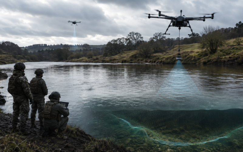
UK Defence Innovation, working on behalf of the Defence Science and Technology Laboratory (Dstl) and the British Army, has opened a £2 million themed competition called Map the Gap Phase 3 to source novel drone-deployed wet gap sensor technologies that can measure ground bearing capacity and conduct underwater river profiling from uncrewed aerial systems. The competition was published on 6 May 2026 with a submission deadline of midday 16 June 2026, and UK Defence Innovation expects to fund three to four proposals across both challenge areas under contracts of up to fifteen months, beginning in October 2026. Each tender must demonstrate capability at technology readiness level six and operate at a stand-off range of three to five kilometres in final deployment. The intent is to remove Royal Engineer reconnaissance teams from the most dangerous part of any opposed river crossing and replace in-person bank surveys with remote, autonomous data capture.
Why is the British Army funding UAS-deployed wet gap sensors after the limitations exposed in the 2021 Map the Gap trials?
The previous Map the Gap competition, run in 2021 under the Defence and Security Accelerator and worth roughly £1.3 million in awarded contracts, gave the British Army a partial answer rather than a deployable capability. Nordic Unmanned demonstrated that its ball-shaped WaFlow instrument could measure water depth and flow speed but could not deliver ground-bearing measurements. Ultrabeam Hydrographic put forward Argonaut 2, an amphibious autonomous survey vehicle bundling LiDAR, sonar, current profiler, and electric cone penetrometer. Digital Concepts Engineering proposed a low signature unmanned air and ground combination, and ISS Aerospace contributed a UAV rotorcraft fitted with photogrammetric and electro-optical infrared cameras.
What the trials surfaced was structural rather than incremental. Bathymetric LiDAR hit penetration limits in turbid water, single platforms were constrained on coverage, mobility, and autonomy, and no one bidder could deliver a high-fidelity wet gap survey end to end. Phase 3 is therefore not a rerun. UK Defence Innovation is asking industry to solve the two specific gaps that defeated the 2021 cohort, with the explicit hope that four years of progress in autonomy, edge AI, sensor miniaturisation, and modular payloads have closed the technical distance.
The other reason for the funding is doctrinal. The Strategic Defence Review and the UK Defence Drone Strategy, backed by at least £4.5 billion of investment over the next decade, have pushed uncrewed and autonomous systems from peripheral capability to mainline force design. Map the Gap Phase 3 is a small line item within that envelope, but it sits at the intersection of three priorities the Ministry of Defence is now treating as non-negotiable: reducing soldier risk in contact tasks, accelerating tempo at the forward edge of battle, and routing more contract value to British and allied small and medium-sized enterprises.
What does the Map the Gap Phase 3 competition actually require from bidders, and how does the £2 million envelope compare to the broader UK defence drone budget?
The competition document specifies two challenge areas. The first is measurement of ground bearing capacity from a UAS, which means estimating, without putting a person or vehicle on the surface, whether the soil can carry the weight of a Challenger 3 main battle tank, a Boxer mechanised infantry vehicle, or supporting bridging plant. The second is underwater river profiling from UAS-deployed sensors or payloads, which covers water depth, flow speed, riverbed contour, and bank approach geometry. Both must be deliverable at a three to five kilometre operator stand-off, which is a meaningful step beyond line-of-sight tactical drones and assumes the platform can survive contested electromagnetic conditions.
Three to four contracts will be awarded across both challenge areas, sharing £2 million excluding VAT. That works out to roughly £500,000 to £670,000 per award over fifteen months, which is consistent with UK Defence Innovation’s pattern of funding prototypes to demonstrable technology readiness rather than full procurement. By comparison, the Ministry of Defence committed approximately $190 million to drones and counter-UAS systems in late 2025 and ringfenced UK Defence Innovation with at least £400 million annually. Map the Gap Phase 3 is therefore a focused engineering challenge inside a much larger uncrewed systems budget, not a strategic capital programme on its own.
The launch webinar is scheduled for 5 May 2026, with one-to-one technical sessions on 13 and 15 May. Bidders must submit by midday on 16 June 2026. The compressed window favours firms that already have flight-tested hardware and existing sensor stacks, and disadvantages those still at concept stage.
Which UK and allied small and medium-sized enterprises are best positioned to compete given recent Ministry of Defence procurement shifts toward British SMEs?
The competitive landscape is shaped less by Map the Gap itself than by the wider procurement reset the Ministry of Defence announced earlier in 2026. Defence Readiness and Industry Minister Luke Pollard has launched the Defence Office for Small Business Growth, set a target of increasing direct SME spending by 50 per cent by May 2028, and committed to compressing average contract negotiation timelines from five years to two. Direct and indirect spending with British SMEs had fallen from 25 per cent to 20 per cent of the £29 billion the department spent with UK companies in 2024, well below the United States Department of Defense benchmark of more than 40 per cent.
Map the Gap Phase 3 reads like exactly the kind of programme designed to sit inside that new SME pathway. The 2021 winners are obvious starting points. Ultrabeam Hydrographic’s Argonaut 2 sensor stack is already aligned with the underwater profiling challenge, although the platform itself is amphibious rather than UAS-deployed and would need re-engineering or partnership with a UAS prime. Digital Concepts Engineering has the air-and-ground systems integration history. ISS Aerospace has the rotorcraft sensor integration credentials. Nordic Unmanned, although Norwegian rather than British, demonstrated relevant capability in the previous round and would qualify under allied NATO partner framing.
Beyond the previous cohort, the addressable bidder universe extends to UK photonics specialists working on bathymetric LiDAR penetration in turbid water, edge AI firms capable of running ground-classification models on board, and modular sensor payload integrators. The Ministry of Defence has explicitly emphasised the need for modular, platform-agnostic sensor packages that can be remounted when platforms fail or when missions require only part of the full survey. That requirement favours companies building open architecture payloads over those tied to proprietary airframes.
How does the Ukraine war’s drone evolution change the technical and operational benchmark for British Army wet gap reconnaissance?
The 2021 baseline assumed a relatively permissive operating environment for surveying drones. The 2026 baseline cannot. Ukraine has demonstrated that first-person view drones, fibre-optic-controlled systems, and electronic warfare countermeasures evolve on a daily cycle, and that any uncrewed system entering contested airspace must assume jamming, spoofing, and short engagement timelines. The European Council on Foreign Relations and other analysts have repeatedly noted that the UAS sector is now in a state of continuous iterative combat development, which raises the specification floor for any system the British Army is willing to deploy at brigade or divisional level.
For Map the Gap bidders, this translates into requirements that go beyond the published challenge document. Survivability against electronic warfare, low-signature flight profiles, autonomous mission completion if the data link drops, and rapid sensor reuse on a replacement airframe are now table stakes, not differentiators. The competition’s three to five kilometre stand-off range is a partial concession to that reality but still well within the engagement envelope of modern short-range air defence and counter-UAS systems.
The wet gap problem also has a doctrinal dimension that did not exist as sharply in 2021. The British Army’s bridging and gap-crossing capability sits inside Future Soldier and the broader Land Tactical Deep Find architecture, and any sensor that can deliver multi-site survey data faster than a Royal Engineer reconnaissance party gives commanders the ability to feint at one crossing while preparing another. The competition document itself notes that increasing the pace, stealth, and number of viable crossing sites will increase operational agility and obfuscate tactical intent. That is a deception-warfare argument, not a survey-efficiency argument, and it changes how the resulting capability is likely to be employed in the field.
What are the execution risks for Map the Gap Phase 3 and what does success or failure mean for the British Army’s broader uncrewed systems roadmap?
Three execution risks stand out. The first is the technology readiness level six requirement. TRL six demands a system demonstrated in a relevant environment, which for wet gap survey means real rivers with real turbidity and real bank conditions, not laboratory tanks. Fifteen months is tight for any bidder that has to develop new sensors rather than integrate existing ones. The second is integration. Ground bearing capacity estimation from the air is fundamentally a soil-mechanics inference problem, not a remote sensing problem, and the bidders most likely to crack it may need to combine LiDAR, synthetic aperture radar, hyperspectral imaging, and ground-penetrating radar in ways that no single vendor currently fields. The third is acquisition. UK Defence Innovation prototypes have a documented history of stalling between Phase 2 demonstration and frontline procurement, which is partly why the Defence Office for Small Business Growth has been set up.
Success would give the British Army something its land forces have lacked since at least the Cold War, namely a remote, multi-site wet gap survey capability that can be tasked from a brigade headquarters and feed bridging decisions in hours rather than days. It would also create export pathways into NATO partners with similar river-crossing doctrine, particularly Germany, Poland, and the Nordic states, all of which face operational geographies dominated by inland waterways.
Failure would not be catastrophic in budget terms, but it would extend the pattern of UK uncrewed systems contests delivering interesting prototypes without operational capability. That, in turn, would reinforce the structural critique that British defence procurement is good at sponsoring innovation and slow at fielding it, which is precisely the reputation the current Ministry of Defence leadership is trying to dismantle.
Key takeaways on what this development means for UK defence SMEs, the British Army, and the wider uncrewed systems industry
- UK Defence Innovation has launched Map the Gap Phase 3 with £2 million in funding for three to four contracts over fifteen months, targeting UAS-deployed sensors for ground bearing capacity measurement and underwater river profiling.
- The competition closes at midday on 16 June 2026, with contracts expected to begin in October 2026 and demonstrations required at technology readiness level six.
- The 2021 Map the Gap competition exposed the penetration limits of bathymetric LiDAR in turbid water and the inability of single uncrewed platforms to deliver a full high-fidelity wet gap survey, and Phase 3 is structured to close exactly those gaps.
- The £2 million envelope is small relative to the UK Defence Drone Strategy’s £4.5 billion ten-year commitment but sits at a strategically important intersection of soldier risk reduction, operational tempo, and SME industrial policy.
- Ultrabeam Hydrographic, Digital Concepts Engineering, and ISS Aerospace are the most obvious incumbents, with Nordic Unmanned a likely allied bidder, although the modular platform-agnostic specification opens the field to new entrants in photonics, edge AI, and sensor integration.
- The Defence Office for Small Business Growth and the Ministry of Defence’s 50 per cent SME spending uplift target by May 2028 create a more favourable contracting environment for British small and medium-sized enterprises bidding into Map the Gap Phase 3 than in any previous round.
- Lessons from Ukraine raise the survivability floor for any deployable system, with electronic warfare resilience, low signature flight, and autonomous mission completion now baseline rather than differentiating requirements.
- Successful delivery would give British Army commanders the ability to survey multiple crossing sites in parallel, supporting deception operations and faster bridging decisions, with potential export pathways into NATO partners across northern and central Europe.
- Failure to convert Phase 3 prototypes into operational capability would reinforce concerns that UK defence procurement sponsors innovation faster than it fields it, which is the precise reputation the current Ministry of Defence procurement reform is designed to reverse.
- For the wider uncrewed systems industry, Map the Gap Phase 3 is a useful signal of where Dstl and the British Army see the sensor frontier moving next, with implications for hydrographic surveying, environmental monitoring, and dual-use commercial applications well beyond defence.
Discover more from Business-News-Today.com
Subscribe to get the latest posts sent to your email.