

A powerful magnitude 7.4 earthquake struck western Colombia on Monday, August 10, 2026, causing injuries and significant structural damage across the Pacific-facing department of Chocó and neighbouring areas while sending people rushing from buildings hundreds of kilometres away in Bogotá. Colombian geological authorities revised the quake upward from earlier estimates and located its epicentre near San José del Palmar, a small municipality in the mountainous interior of Chocó.
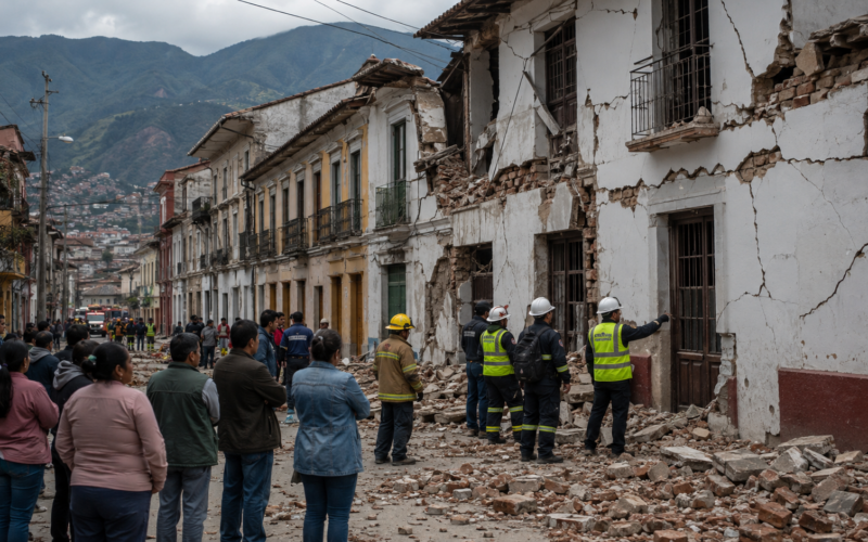
Chocó Governor Nubia Carolina Córdoba-Curi said authorities had received reports of injuries and serious damage to buildings in the departmental capital, Quibdó, while Risaralda Governor Juan Diego Patiño described severe damage in Pereira, where building facades collapsed and residents were injured. Emergency authorities were still conducting assessments on Monday evening, meaning the full casualty and property-loss picture remained incomplete.
The Colombian Geological Service placed the earthquake at a depth of about 96 kilometres, while the United States Geological Survey reported a somewhat deeper estimate of around 107 kilometres. Those differences are normal as seismic agencies refine location calculations using separate monitoring networks, but both assessments confirm that the quake was a major regional event rather than a shallow local tremor. No tsunami warning was issued because the earthquake originated inland and at substantial depth.
The shaking was strong enough to be felt across Bogotá and into neighbouring countries. Reuters witnesses reported tremors in Venezuela’s Táchira state and Barquisimeto, while the Associated Press said people also felt the quake in Ecuador. Bogotá Mayor Carlos Fernando Galán said no major damage had been reported in the Colombian capital during the initial assessment.
Where was the August 10 Colombia earthquake centred and why was the magnitude revised to 7.4?
The earthquake’s epicentral area was near San José del Palmar in Chocó, approximately 400 kilometres west of Bogotá. The municipality lies in a rugged part of western Colombia close to the Andes and the Pacific region, where communities can be difficult to reach quickly after landslides, road damage or communications failures.
Initial international reports referred to a magnitude 6.8 event based on the European-Mediterranean Seismological Centre estimate. Colombia’s Geological Service subsequently revised the magnitude to 7.4 as additional seismic data became available, and the United States Geological Survey also reported the stronger magnitude. That updated figure is therefore the more appropriate number for describing the August 10 earthquake as assessments continue.
Magnitude revisions frequently occur during the first minutes or hours after a major earthquake because automated systems begin with limited data. As information from more seismic stations arrives, scientists can calculate the location, depth and energy release more accurately. A revision from the high-6 range into the mid-7 range is meaningful because earthquake magnitude uses a logarithmic scale, so relatively small numerical changes represent substantial differences in energy release.
The depth is equally important. Deeper earthquakes can transmit shaking across much wider areas while sometimes producing less concentrated surface destruction close to the epicentre than shallow earthquakes of comparable magnitude. Monday’s quake was nevertheless powerful enough to damage buildings across multiple western Colombian cities despite its substantial depth.

How serious is the reported earthquake damage in Quibdó, Pereira and other Colombian cities?
The clearest early reports of damage came from Quibdó and Pereira, although local authorities were still assessing surrounding municipalities. Chocó’s governor said there were injuries and significant damage to buildings in Quibdó, a city of roughly 130,000 people, while warning residents about the possibility of aftershocks.
In Pereira, Risaralda Governor Juan Diego Patiño described the situation as severe and said images showed collapsed facades and injured residents. Photographs and local video from western Colombia also showed damage to homes and smaller structures, while the Associated Press reported that part of the neo-Gothic cathedral in Manizales was damaged when one of its towers collapsed onto the building.
Authorities had not announced a confirmed nationwide death toll or comprehensive injury count when the first assessments were released. That uncertainty is important because remote communities around Chocó may require several hours before emergency teams can inspect homes, roads and public buildings, particularly if the earthquake has disrupted transport or communications.
Colombia’s National Unit for Disaster Risk Management said it was coordinating with local authorities to verify damage across the affected region. President Abelardo De La Espriella said he would personally oversee recovery efforts and establish an emergency centre in San José del Palmar, placing national attention directly on the epicentral area.
Why could aftershocks create additional danger after Colombia’s magnitude 7.4 earthquake?
Aftershocks are expected following major earthquakes because the surrounding crust continues adjusting after the initial rupture. Most aftershocks are weaker than the main event, but some can still be powerful enough to damage buildings that were weakened by the original shaking.
That creates a particularly difficult problem in cities where walls, facades, roofs or structural components have already cracked. A building that remained standing after the magnitude 7.4 earthquake may no longer possess its original safety margin, meaning residents should follow inspection and evacuation instructions rather than assuming that visible survival guarantees structural stability.
Chocó Governor Córdoba-Curi specifically raised concern about aftershocks while authorities began their assessment. Emergency teams will therefore need to inspect hospitals, schools, bridges, government buildings and residential structures while remaining prepared for renewed shaking during rescue and recovery operations.
The danger can extend beyond buildings. Earthquakes in mountainous terrain can destabilise slopes and trigger rockfalls or landslides, particularly where soils were already saturated or terrain was susceptible to movement. San José del Palmar has previously appeared in Colombian disaster-risk alerts for landslide susceptibility, reinforcing the need for authorities to monitor roads and slopes around the epicentral region after Monday’s shaking.
Why did the Colombia earthquake cause strong shaking as far away as Bogotá, Ecuador and Venezuela?
The combination of large magnitude and substantial depth helped seismic waves travel across a broad geographic area. People in Bogotá, roughly 400 kilometres from the epicentre, evacuated some buildings after feeling prolonged movement, while reports of shaking also came from Venezuela and Ecuador.
Deep earthquakes can be felt across large regions because seismic energy travels outward through the crust and upper mantle rather than dissipating entirely near the surface. Local geology then determines how strongly individual cities experience that energy, with soft sedimentary basins sometimes amplifying shaking compared with areas built on firmer rock.
Bogotá’s mayor reported no major damage during the initial review, which is encouraging given the capital’s population and concentration of high-rise buildings. The absence of major damage there does not provide a reliable guide to conditions closer to the epicentre, where structural vulnerability and stronger ground motion may produce substantially different outcomes.
The shaking in Venezuela carries additional emotional significance because the country suffered devastating twin earthquakes in late June. Reuters reported that those disasters killed more than 6,000 people, meaning Monday’s tremor was felt by communities that had only recently experienced catastrophic seismic damage.
Why was there no tsunami warning despite such a powerful magnitude 7.4 earthquake?
A large earthquake does not automatically create a tsunami. The most dangerous tsunami-generating earthquakes usually occur beneath or close to the ocean floor and involve vertical displacement capable of moving enormous volumes of seawater.
Although Colombia’s earthquake affected the Pacific region, the epicentre was located inland near San José del Palmar and at considerable depth. The United States tsunami warning system therefore reported that no tsunami warning was required.
This distinction matters because the Colombian and Ecuadorian Pacific coasts are historically vulnerable to tsunami-generating earthquakes. One of the region’s most destructive seismic events occurred in 1906, when an estimated magnitude 8.8 earthquake off Ecuador and Colombia generated a tsunami that killed around 1,500 people.
Monday’s earthquake has a very different source geometry, which substantially reduces that particular hazard. Coastal communities still need to follow official guidance after any major regional earthquake, but the immediate emergency on August 10 is focused on structural damage, injuries, aftershocks and possible landslides rather than tsunami evacuation.
Why is western Colombia particularly vulnerable to major earthquakes and complex seismic activity?
Colombia sits within one of the world’s most tectonically active regions, where several major geological plates and smaller tectonic blocks interact. The Nazca Plate moves beneath the South American Plate along Colombia’s Pacific margin, producing frequent earthquakes and contributing to the volcanic systems running through the Andes.
The country therefore experiences several different categories of earthquake. Some occur along shallow crustal faults, while others originate deeper within the subducting Nazca Plate. The August 10 earthquake’s depth suggests it belongs to the latter category, although a detailed geological interpretation will depend on analysis from Colombia’s Geological Service.
The wider region forms part of the Pacific Ring of Fire, a zone stretching around much of the Pacific Ocean where tectonic boundaries generate a high concentration of earthquakes and volcanic activity. Colombia’s combination of coastal subduction, mountainous terrain and rapidly growing urban centres makes disaster preparedness especially important.
Earthquake risk is determined not only by magnitude but by where people live and how buildings were constructed. Modern engineering standards can dramatically reduce collapse risks, while older or informal structures may remain much more vulnerable even when they experience the same ground shaking.
How could earthquake damage become particularly difficult to assess across Chocó?
Chocó presents logistical challenges that distinguish the earthquake response from one centred entirely on a major metropolitan area. The department contains dense rainforest, mountainous terrain, extensive river networks and communities that have comparatively limited road access.
San José del Palmar itself has a population of only several thousand people, but the surrounding terrain means authorities may need to inspect dispersed settlements rather than a single concentrated urban zone. The Associated Press placed the municipality’s population at around 4,800.
Road damage or landslides could complicate access precisely when emergency teams need to inspect structures and provide medical assistance. Telecommunications outages can also delay information, creating situations in which the first national casualty figures understate conditions in remote communities.
That is why initial earthquake totals should be treated as provisional. The absence of confirmed deaths in the earliest hours is encouraging, but the scale of the disaster will become clearer only after local authorities complete assessments across Chocó, Risaralda and other western departments.
What should residents expect as Colombia begins inspecting buildings and infrastructure?
The first operational priority will be identifying damaged buildings that cannot safely be reoccupied. Engineers and emergency officials will need to inspect hospitals, schools, apartment blocks, bridges, roads and public facilities while utility operators examine electricity, water and communications systems.
Residents may find that buildings apparently intact from the outside remain closed until structural assessments are completed. Cracks around columns, load-bearing walls or foundations can create hidden hazards, particularly if further aftershocks occur.
Transport corridors will also be important because western Colombia’s mountainous geography makes communities vulnerable to isolation when roads are blocked. Landslide inspections may therefore continue even in places where the earthquake caused relatively little direct building damage.
Emergency authorities will also monitor the aftershock sequence. A decreasing pattern would gradually lower immediate risk, while a significant secondary earthquake could create additional damage and force renewed evacuations.
What are the key takeaways from Colombia’s magnitude 7.4 earthquake on August 10?
- Colombia’s Geological Service revised the August 10 earthquake to magnitude 7.4, with the epicentre near San José del Palmar in Chocó and a reported depth of around 96 kilometres.
- Authorities reported injuries and significant building damage in Quibdó, while serious structural damage and injured residents were also reported in Pereira.
- The Associated Press reported damage in several western Colombian cities, including the collapse of part of the cathedral in Manizales, while the full regional damage assessment remains underway.
- The earthquake was felt across Bogotá and into neighbouring Venezuela and Ecuador, showing the unusually wide footprint produced by the major, relatively deep seismic event.
- Bogotá Mayor Carlos Fernando Galán said no major damage was reported in the Colombian capital during the initial assessment.
- The United States tsunami warning system issued no tsunami warning, with the principal risks instead centred on damaged buildings, aftershocks and possible landslides.
- President Abelardo De La Espriella said he would oversee the response and establish an emergency centre in San José del Palmar as authorities assess conditions close to the epicentre.
- The casualty picture remains preliminary, particularly in remote parts of Chocó where mountainous terrain and potential road damage could slow inspections and emergency access.
Why the next several hours will determine whether Colombia’s earthquake becomes a much larger disaster
The magnitude 7.4 reading immediately places the August 10 earthquake among the most consequential seismic events to affect Colombia in recent years, but magnitude alone will not determine its eventual human cost. The relatively deep epicentre helped spread shaking across an enormous region, while potentially reducing some of the extremely concentrated destruction that a comparably powerful shallow earthquake could produce directly above the rupture.
The greatest uncertainty now lies in Chocó. Authorities already know that Quibdó has suffered significant structural damage, yet smaller communities closer to San José del Palmar may take longer to assess because the department’s geography complicates road access and communications. Damage to vulnerable structures or earthquake-triggered landslides could therefore alter the picture considerably as emergency teams reach more remote areas.
Pereira and other cities also require careful inspection because collapsed facades show that shaking was capable of compromising structures well outside the epicentral municipality. The absence of major damage in Bogotá is reassuring, but western Colombia remains the central concern as engineers determine which buildings can safely be occupied and authorities prepare for aftershocks.
The response will ultimately be judged not only by the number of casualties but by how quickly Colombia can identify unstable buildings, keep vulnerable residents away from damaged structures and maintain access to communities across difficult terrain. Monday’s first reports already establish that this was not merely a large earthquake recorded by instruments. It was a damaging regional event, and the scale of its consequences will become much clearer as daylight inspections, aftershock monitoring and local assessments continue.
Discover more from Business-News-Today.com
Subscribe to get the latest posts sent to your email.