

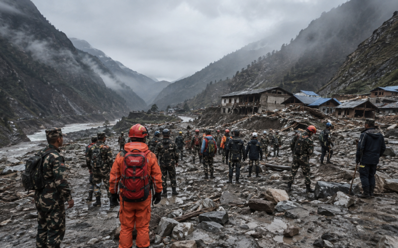
Rescuers are searching for hundreds of missing people across the Nepal-Tibet border after an enormous ice-and-rock avalanche sent a devastating surge through Himalayan river valleys on August 26, killing at least 160 people across Nepal and China and destroying villages, roads, hydropower facilities and infrastructure used by international tourists and religious pilgrims.
Reuters reported early on August 27 that at least 157 deaths had been confirmed in Nepal and three in Tibet. The figures remain preliminary and could rise substantially because hundreds of people remain unaccounted for, including foreign visitors from countries such as India, the United States, Britain, Canada, Australia and South Korea.
The disaster appears to have originated high in the mountains near the border when a large mass of glacier ice and rock collapsed into a steep valley and generated a fast-moving debris surge through the Lhende Khola system. Scientists are still investigating what initiated the collapse, with seismic activity and unusually warm conditions among the factors being examined.
What happened in the mountains before the flood devastated Nepal’s Rasuwa district?
Satellite analysis indicates that a large section of glacier or ice-covered mountain terrain at roughly 5,200 metres elevation broke away and fell more than a kilometre into the valley below. The impact released an enormous quantity of ice, rock, mud and water into the river system, rapidly transforming a local mountain collapse into a high-energy flood capable of travelling far downstream.
Seismic instruments detected a magnitude-4.4 event around the period of the disaster, but researchers have not established whether an earthquake triggered the collapse or whether the seismic signal partly reflected the enormous mass of rock and ice hitting the valley. That distinction requires detailed geological analysis and should not be resolved from timing alone.
The flood travelled through narrow Himalayan valleys where water and debris could accelerate rapidly. Reuters reported that downstream river levels rose by as much as nine metres within around half an hour in some areas, leaving communities with little time to move away from the channel.
The composition of the surge made it especially destructive. Unlike ordinary river flooding, an ice-rock avalanche can carry boulders, sediment, trees and structural debris with enormous force, destroying bridges and buildings while simultaneously burying areas under thick material that later makes rescue difficult.

Why are so many tourists and foreign nationals among the missing?
The affected border corridor is an important route for trekkers, workers and religious pilgrims travelling towards Kailash Mansarovar in Tibet. August is a busy period for movements through the region, meaning the flood struck an area containing considerably more people than its permanent mountain population alone would suggest.
Nepalese authorities have reported hundreds of tourists unaccounted for, including roughly 340 foreign nationals in one of the latest tallies. These numbers remain fluid because disrupted communications make it difficult to distinguish someone genuinely caught in the disaster from a traveller whose location simply has not yet been confirmed.
South Korea has separately confirmed nine workers missing from a hydropower project near the border. Other governments are checking lists of citizens who had registered travel or pilgrimage plans and coordinating with Nepalese authorities to determine whether they were in the affected corridor.
That process is complicated by the destruction of roads and communications infrastructure. Mobile networks can fail during a major mountain disaster, while travellers may have crossed into locations where passenger records are incomplete or held by different tour operators.
For families abroad, official confirmation may therefore take considerably longer than the rapid circulation of preliminary missing-person figures on social media.
How badly have roads, villages and hydropower infrastructure been damaged?
Rasuwa and neighbouring districts contain steep roads, river crossings and hydropower developments built within valleys where suitable flat land is scarce. The same geography that makes these projects possible can expose them to catastrophic flood and landslide forces when material suddenly descends from higher elevations.
Reports from the affected region describe homes, roads, bridges and power installations being swept away or buried. The border trading area around Timure and the Gyirong crossing also sustained severe damage, interrupting one of the important connections between Nepal and Tibet.
China reported significant casualties and missing people around Gyirong port, where roads and communications were severed. President Xi Jinping ordered an all-out search-and-rescue effort, and Chinese authorities activated a national Level-II disaster response while mobilising firefighters, military personnel, engineering teams and specialised detection equipment.
China’s emergency ministry said 249 national fire and rescue personnel and another 325 engineering rescuers were dispatched, while approximately 30,000 relief items including tents, heaters, bedding and folding beds were allocated to affected communities.
Nepal’s ability to reach remote sites has been constrained by damaged roads, high water and the limited number of locations where helicopters can land safely. Those access problems mean casualty and missing-person figures may remain incomplete for some time.
Did climate change cause the Nepal-Tibet glacier disaster?
Scientists are examining climate conditions as one part of the disaster rather than assigning a single cause before the physical sequence is fully understood. Himalayan glaciers have lost substantial ice mass over recent decades as regional temperatures rise, and researchers have documented faster melting and growing instability across parts of the high-mountain cryosphere.
Warmer temperatures can weaken glaciers and permafrost, alter meltwater pressure and increase the probability of certain types of slope failure. They can also enlarge or destabilise glacial lakes, creating additional flood hazards when natural ice or moraine dams fail.
None of those mechanisms proves that climate change directly triggered this particular collapse on August 26. Investigators still need to examine local geology, the detected seismic event, recent weather, glacier structure and the exact location from which the ice-rock mass detached.
The distinction is important because climate change affects baseline risk rather than necessarily providing the immediate trigger for every individual disaster. A warming mountain environment can become more unstable even when the final collapse is initiated by an earthquake, slope failure or another short-term event.
What is already established is that the Himalayas are experiencing rapid environmental change while human settlement, roads, hydropower and tourism infrastructure continue expanding into narrow high-risk valleys.
Why could the disaster have consequences downstream in India as well?
The rivers emerging from Nepal’s Himalayan valleys ultimately connect with much larger river systems flowing into northern India. A sudden upstream flood can therefore propagate across national boundaries even after the most destructive debris has settled closer to the mountain source.
Indian authorities issued alerts in downstream areas and moved thousands of people from vulnerable locations in Bihar as water levels were monitored. Those evacuations demonstrate that a disaster originating near the Nepal-Tibet frontier can become a multi-country emergency within hours.
The immediate downstream threat depends on how much water remains in the river system, whether additional landslides block valleys and subsequently fail and how monsoon rainfall develops. Secondary landslides are a particular concern because slopes disturbed by the first event can continue collapsing during rescue operations.
Authorities in both Nepal and China have consequently warned rescuers about secondary hazards rather than focusing exclusively on recovering victims from the initial flood zone.
The August 26 disaster is already among the deadliest Himalayan events of recent years, but its final scale is not yet known. Rescue teams are still trying to answer the most urgent question, which is how many people remain alive in communities and work sites cut off from normal access. The longer-term investigation will then need to determine how a high-altitude collapse became a cross-border catastrophe and whether increasingly populated Himalayan valleys can be protected from events that move from mountain summit to settlement in minutes.
Discover more from Business-News-Today.com
Subscribe to get the latest posts sent to your email.