


San Antonio continues to recover from one of the most intense flash flooding events in recent memory after torrential rainfall on June 12, 2025, overwhelmed the city’s infrastructure and waterways. Authorities confirmed on Saturday that the death toll has risen to 13, and that all previously missing individuals have now been found. This announcement follows two days of search and recovery operations after more than six inches of rain fell within hours, inundating low-water crossings, sweeping away vehicles, and forcing dozens to seek refuge in trees and brush.
What makes the San Antonio June 2025 flooding one of the most destructive in recent history?
According to the National Weather Service, more than 6.11 inches of rain fell over San Antonio on June 12, making it the second-wettest June day on record and one of the top ten rainiest days in the city’s history. The deluge occurred within a concentrated timeframe, rapidly swelling creeks and submerging roadways across the region. The primary trigger was a stalled frontal system interacting with moisture from the Gulf of Mexico, resulting in widespread flash flooding conditions.
San Antonio’s topography, with numerous low-water crossings and shallow creekbeds like Beitel Creek and Salado Creek, made it particularly susceptible to rapid water accumulation. These areas became flashpoints during the storm, with dozens of vehicles swept downstream in minutes.
Which victims have been publicly identified and what does it reveal about the flooding’s human toll?
The Bexar County Medical Examiner’s Office has confirmed the identities of several of the deceased. Among them were Martha De La Torre Rangel (55), Victor Manuel Macias Castro (28), Matthew Angel Tufono (51), Christine Gonzalez (29), Rudy Garza (61), Jose Pinadelatoore (28), and Andrew Sanchez (60). These individuals were primarily found in and around the Perrin Beitel Creek area.
The death of Stevie Richards, 42, became one of the most widely reported tragedies. His wife, Angel Richards, told the San Antonio Express-News she had been on the phone with him as floodwaters overtook his car. “As I was talking to him, he said, ‘Oh, the car’s floating’… and then I could hear the water take the phone,” she said. His vehicle was later found submerged miles downstream.
Additional victims, including Brett Riley (63), were discovered outside the central search zone, highlighting the expansive reach of the floodwaters. These stories have gripped the city and underscored how quickly the flood turned deadly for people in low-lying areas.
How did emergency crews respond, and what challenges did they face during rescues?
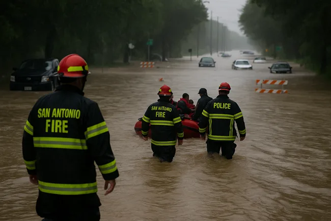
The San Antonio Fire Department performed more than 70 rescue operations during the peak of the flooding, often navigating treacherous conditions with limited visibility and powerful currents. Firefighters pulled individuals from trees, flooded cars, and thick brush as far as a mile downstream from where their vehicles had been swept away.
Beitel Creek, near Loop 410 and Perrin Beitel Road, became the focal point of rescue efforts. More than a dozen vehicles were found clustered, overturned or submerged. Search dogs and swift water units were deployed throughout Thursday and Friday, and helicopter crews surveyed affected areas from above.
Emergency personnel reported encountering large debris fields, strong undercurrents, and high water levels that shifted rapidly. In several instances, crews had to improvise rope rescues and coordinate rescues from trees where stranded individuals had clung to branches overnight.
What does San Antonio’s flood history tell us about infrastructure gaps and risk exposure?
San Antonio has faced devastating floods before, most notably in September 1921 when more than 200 people died after a hurricane’s remnants caused the San Pedro Creek to burst its banks. That event led to the construction of Olmos Dam and the city’s iconic flood bypass channels, which eventually formed the basis for the River Walk.
More recently, deadly floods in 1998 and 2002 also exposed vulnerabilities in the city’s drainage systems. While projects such as the San Pedro Creek Culture Park and multiple stormwater retention basins have improved resilience, experts warn that the current network may be insufficient for the increasing frequency and intensity of extreme weather events.
Urban sprawl and the reduction of permeable ground cover have further amplified runoff volumes. Planners now face calls to expand green infrastructure, upgrade drainage systems, and reinforce aging flood-control assets in light of the latest disaster.
What are officials and institutions saying in the wake of the deadly flooding?
San Antonio Mayor Ron Nirenberg expressed condolences on Friday, stating, “Our hearts are with the families of those we’ve lost to this week’s flash floods and the families who continue searching for their loved ones.” Emergency personnel across Bexar County echoed similar sentiments, praising the bravery of first responders while acknowledging the emotional toll of the recovery mission.
The National Weather Service issued multiple flash flood warnings in advance of the storm and reiterated afterward that flash floods are the deadliest form of weather in the U.S., often underestimated by motorists and pedestrians. The agency emphasized that even six inches of rapidly moving water can destabilize and sweep away a vehicle.
Public safety officials across Texas used this moment to encourage stronger compliance with “Turn Around, Don’t Drown” advisories. Social media campaigns and automated mobile alerts are also being evaluated for improvement following Thursday’s deadly outcomes.
What is the status of cleanup and what are current weather concerns following the flooding?
As of Saturday, floodwaters have largely receded across the affected zones, and cleanup operations are underway. Damaged vehicles have been removed from creekbeds, and street crews have begun clearing debris from major thoroughfares and neighborhoods.
However, the National Weather Service warned that post-flood heat could bring its own risks. Heat indices between 103–106°F were expected across South Texas over the weekend, posing a threat of heat exhaustion and dehydration, especially for those involved in manual recovery efforts. First responders have been advised to rotate personnel frequently and monitor vulnerable residents in flood-hit areas.
Weather forecasts suggest a return to more typical early-summer conditions later in the week, though officials have warned that the ground remains saturated, and even moderate rainfall could reintroduce localized flooding threats.
Why are urban flash floods becoming more intense, and what policy shifts could follow this event?
Climate scientists note that flash flood events like this one are becoming more frequent and more severe due to a warming climate. Warmer air holds more moisture, increasing the likelihood of high-volume downpours. At the same time, increased development in floodplains and reduced natural absorption capacity contribute to faster water accumulation.
This week’s floods may intensify calls for federal and state investment in adaptive infrastructure. Urban planning groups in San Antonio are urging an acceleration of green stormwater management initiatives, including bioswales, permeable pavement, and large-scale retention basins.
At the state level, legislators may consider expanding grant programs for municipal drainage upgrades, and there is renewed discussion of whether current zoning and construction codes account for climate-driven flood risk. The Texas Water Development Board is expected to include the San Antonio flooding event in its next round of project planning.
Discover more from Business-News-Today.com
Subscribe to get the latest posts sent to your email.