


Tropical Storm Melissa is intensifying in the Caribbean Sea as island nations brace for potentially dangerous impacts in the days ahead. While current models indicate the storm may not make landfall in the United States, forecasters are warning that Melissa could strengthen into a major hurricane by early next week, posing serious risks to Haiti, Jamaica, and the Dominican Republic.
The storm’s trajectory remains highly uncertain due to weak steering currents, and while the National Hurricane Center currently projects a west-northwest track confined to the Caribbean basin, atmospheric shifts could alter the path suddenly. That’s why American forecasters are urging East Coast residents not to ignore the storm just yet.

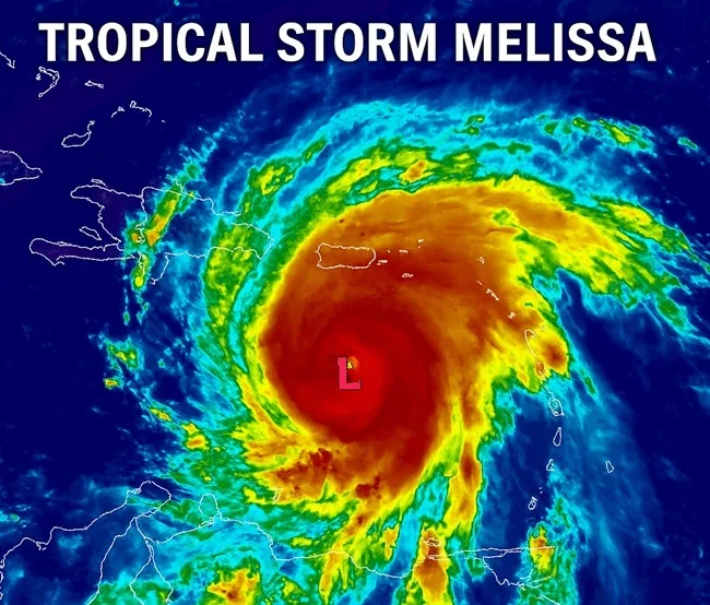
Where is Tropical Storm Melissa headed and which areas are under immediate threat?
As of the latest update from the National Hurricane Center, Tropical Storm Melissa is situated several hundred miles south-southwest of Port-au-Prince, Haiti, and moving slowly west to northwest. Maximum sustained winds are hovering near 50 miles per hour, but the system is tracking over extremely warm waters—fertile ground for rapid intensification.
Hurricane watches have already been issued for southern Haiti, while tropical storm watches are in place for Jamaica. Meteorologists say Melissa has a strong chance of reaching hurricane strength within the next 48 hours, potentially becoming a Category 3 storm if it maintains its path and pace.
Jamaica’s Meteorological Service has issued public alerts in flood-prone parishes such as Clarendon, St. Elizabeth, and Manchester. In Haiti, already struggling with political turmoil and infrastructure breakdowns, the forecast is far more dire. Rainfall estimates of up to 10 inches could trigger flash floods and deadly mudslides across mountain regions and deforested areas—especially in and around Port-au-Prince.
Why is Melissa’s slow movement raising red flags for forecasters and regional governments?
One of the most concerning variables for forecasters is Melissa’s sluggish motion. The storm is caught in an area of weak steering currents, which not only makes its path difficult to predict but also increases the chance of prolonged rainfall over any region it lingers near.
This stalling effect could be catastrophic for Haiti and Jamaica, where already-vulnerable communities may face prolonged flooding. In some mountainous zones of Hispaniola, even modest rainfall can rapidly lead to erosion and slope failure. Emergency management authorities in both countries are urging residents to secure homes, stock essential supplies, and follow evacuation guidance where applicable.
The slow speed also makes Melissa a higher-risk candidate for rapid intensification. Warm sea surface temperatures, low wind shear, and deep moisture all combine to potentially turbocharge the system in a short period. Forecasters are watching for signs of such a leap, which could change both the storm’s severity and its path.
What are the forecast models saying about possible impacts to the U.S. mainland?
While the majority of storm models keep Melissa south of the U.S. mainland, some outlier models still suggest a late northward turn is possible. These projections would potentially bring Melissa’s outer bands close to the southeastern coast of the United States, particularly Florida and the Carolinas. However, as of now, these scenarios are considered low probability.
Meteorologists at the National Oceanic and Atmospheric Administration are maintaining close watch, particularly for any shifts caused by upper-level troughs or high-pressure ridges that could redirect the storm. Residents along the Gulf Coast and southeastern seaboard are being advised to stay informed but not panic.
Should Melissa remain over open waters, the U.S. impact could be minimal. However, even distant storms can cause rip currents, elevated surf, and shipping disruptions along the Atlantic and Gulf coastlines.
How are Caribbean nations preparing for infrastructure disruptions and humanitarian risks?
The economic and social vulnerability of many Caribbean nations compounds the risks posed by Tropical Storm Melissa. In Haiti, where civil unrest and poverty already limit state capacity, the storm could overwhelm emergency services and delay international aid distribution. Port closures, power outages, and displacement are all likely scenarios if the storm tracks closer to shore.
Jamaica’s disaster preparedness agency has activated emergency shelters and logistical response plans, including provisions for COVID-era health protocols. The Dominican Republic is also under heightened alert, with contingency planning underway for coastal and interior flooding.
Agricultural zones across the region are expected to suffer significant losses. In Jamaica, banana and sugar cane crops are particularly at risk. In Haiti, subsistence farming regions could see complete crop destruction, further straining already precarious food security levels.
What are the potential insurance and market implications from Melissa’s path?
Reinsurance firms and parametric insurers are closely monitoring Tropical Storm Melissa’s intensity and rainfall metrics. The Caribbean Catastrophe Risk Insurance Facility, backed by the World Bank, may issue payouts depending on Melissa’s final path and severity. Modelled loss scenarios currently focus on infrastructure and agricultural damage in Haiti and Jamaica.
Commodity traders are also watching for shipping disruptions. The Caribbean serves as a key transit route for refined petroleum products, aluminum, and various perishable exports. Any port closures could create short-term volatility in select commodities.
Cruise lines have already begun to reroute vessels scheduled to stop in the western Caribbean this weekend, with changes confirmed for ships bound for Jamaica, the Cayman Islands, and the Dominican Republic.
How does Melissa fit into broader climate trends and late-season storm activity?
October is historically one of the most active months for Atlantic storms, particularly in the Caribbean basin. But this season stands out due to unseasonably high sea surface temperatures, which extend the window for hurricane formation and intensification.
Tropical Storm Melissa is emblematic of this new pattern: a system forming in a low-shear, high-heat environment with the potential for erratic movement and explosive development. Forecasters say it’s another example of how climate change is reshaping the character of hurricane season—making storms not only more powerful, but less predictable.
Melissa’s development also underscores the increasing importance of satellite forecasting and cross-border collaboration. Agencies including the National Hurricane Center, the United Nations Office for the Coordination of Humanitarian Affairs, and regional disaster response teams are working in tandem to monitor the situation and prepare for rapid response should landfall occur.
What should residents and stakeholders expect in the coming days?
Over the next 72 hours, the key watchpoints will include any changes in Melissa’s speed, wind speed increases indicating intensification, and any shifts northward. Rapid intensification could occur with little warning, and that would require immediate reassessment of risk zones.
For residents in the Caribbean, particularly Haiti and Jamaica, the next two to three days are critical. Government agencies are urging communities in low-lying and mountainous areas to evacuate preemptively if advised, and to prepare for power outages, road blockages, and supply chain disruptions.
For U.S. stakeholders, the focus remains on observing for potential secondary effects—such as shipping delays, commodity fluctuations, and indirect weather impacts from Melissa’s extended rainbands.
Key takeaways: Tropical Storm Melissa’s evolving track, risk zones, and regional fallout
- Tropical Storm Melissa continues to strengthen in the central Caribbean with a high probability of becoming a hurricane in the coming days.
- Forecasts indicate a direct hit to the United States is unlikely, but steering currents remain weak, and a northward turn cannot be fully ruled out.
- Haiti, Jamaica, and the Dominican Republic face immediate risks of flooding, landslides, and prolonged power outages from heavy rain and high winds.
- Meteorologists warn of potential rapid intensification as the storm passes over unusually warm waters in a low-shear environment.
- Insurance and commodity markets are watching for storm-triggered disruptions to shipping, agriculture, and infrastructure in the Caribbean.
- Disaster response agencies are on high alert, with emergency shelters activated and humanitarian teams pre-positioned across high-risk areas.
Discover more from Business-News-Today.com
Subscribe to get the latest posts sent to your email.