


Why torrential rains have turned Darjeeling’s fragile slopes into a scene of devastation
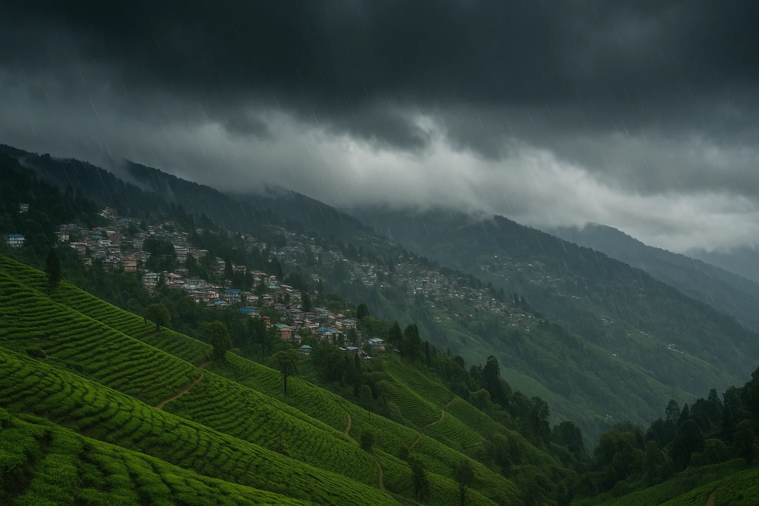
Darjeeling, the jewel of the Eastern Himalayas, has been battered by one of its worst monsoon episodes in years. Relentless rain since October 4, 2025, triggered a chain of deadly landslides that have claimed at least 18 lives, with several others missing. Whole villages have been buried under mud and debris, bridges have collapsed, and vital roads have vanished beneath torrents of slush.
Rescue officials said the damage was most severe in the Mirik, Kurseong, and Sukhia Pokhri regions, where the steep terrain and saturated slopes gave way overnight. The Dudia iron bridge, a critical lifeline connecting Kurseong and Mirik, was swept away, isolating the hill towns and cutting off access to essential relief routes. The Darjeeling–Siliguri highway, the main artery linking the hills to the plains, remains blocked at multiple points.
Meteorological records showed that the district received more than 180 millimetres of rain within 24 hours, one of the heaviest single-day downpours in recent memory. The India Meteorological Department (IMD) has maintained a red alert for Darjeeling, Kalimpong, and Jalpaiguri, warning that more heavy rain is expected in the next 48 hours.

How rescue teams are racing against time as terrain, weather, and isolation compound the crisis
By Sunday evening, five teams of the National Disaster Response Force (NDRF), along with state police and Army personnel, were battling landslides, blocked roads, and flooding to reach stranded communities. With telecommunication lines down in several pockets, authorities relied on satellite phones and local volunteers to transmit distress calls.
The West Bengal government has set up a 24×7 control room in Nabanna, and Chief Minister Mamata Banerjee is expected to visit the affected areas on October 6. The administration has announced ₹2 lakh ex-gratia for each family of the deceased and directed officials to restore connectivity “on war footing.”
Rescue operations are proving extremely difficult. Helicopter sorties are limited due to continuing rain and low visibility. Bulldozers and excavators are unable to reach several sites where the roads themselves have collapsed. Local residents are forming human chains to move debris and pull survivors out of partially submerged homes.
Several villages — including Sarsaly, Dhar Gaon, Jasbirgaon, and Nagrakata — remain inaccessible. In Dhar Gaon alone, entire clusters of homes were flattened. Officials reported that four people were rescued alive after being trapped for hours beneath mud and rubble. But the same officials cautioned that the casualty count may rise as operations continue through the night.
Why Darjeeling’s geography makes every monsoon a potential disaster waiting to happen
Experts say Darjeeling’s disaster was not just a result of the monsoon, but also of structural neglect. The region’s steep slopes, deforested hillsides, and unregulated construction make it one of the most vulnerable mountain zones in India. Every year, a combination of road cuts, unchecked urban expansion, and aging infrastructure chips away at the land’s natural stability.
Climate scientists point to an increase in extreme rainfall events across the sub-Himalayan region — short, intense bursts that dump massive volumes of water in a few hours. Such events saturate the soil faster than it can drain, setting off chain reactions of landslides. Urbanisation without proper drainage, coupled with indiscriminate hillside excavation, worsens the risk.
The result is a dangerous feedback loop: each year’s monsoon leaves behind scarred slopes that are more likely to collapse the next. The Darjeeling–Kalimpong–Sikkim corridor, with its booming tourism and tea economy, now sits atop this unstable terrain, amplifying both human and economic risk.
How the rains exposed infrastructure and coordination gaps across North Bengal and Sikkim
The scale of disruption goes beyond Darjeeling. National Highway-10 and NH-717A, key lifelines connecting West Bengal to Sikkim, have been blocked by multiple slides. Road networks leading to Kalimpong and Siliguri are choked with debris. Even secondary access routes via Peshok and Teesta Bazaar are severely damaged.
Authorities said over a dozen bridges have been washed away or weakened, isolating hundreds of families. Restoration work is complicated by the continuing downpour, which is also threatening low-lying parts of Jalpaiguri and Alipurduar with floods. Water levels in several rivers have risen sharply following dam overflows in Bhutan, which share hydrological linkages with North Bengal’s river systems.
For businesses and tea estates, the consequences are immense. Roads used to transport tea from the hills to the plains are blocked, labour mobility is restricted, and electricity lines have been snapped in multiple estates. The Darjeeling tea industry, already struggling with declining yields and climate pressure, faces another blow to production.
How the Darjeeling tragedy is exposing India’s disaster-readiness gap and testing policy accountability
At the policy level, both state and central leaders are calling for structural resilience. Prime Minister Narendra Modi and Home Minister Amit Shah have assured that the Union government is monitoring the crisis and will provide all logistical and financial aid required.
State ministers and local administrators, however, privately acknowledge that relief logistics are hindered by the terrain itself. Narrow, winding roads through high-altitude zones are easily compromised. Even minor blockages take hours to clear. Analysts have noted that despite repeated monsoon disasters in North Bengal, slope stabilisation and drainage reinforcement projects have lagged due to funding and bureaucratic delays.
Environmental researchers have long urged for a Darjeeling landslide mitigation masterplan, integrating satellite-based early warning systems and strict zoning enforcement. Without these, the region risks turning annual rainfall into a cycle of recurring tragedy.
What the disaster means for climate preparedness, policy accountability, and Himalayan resilience
The Darjeeling calamity is another reminder that Himalayan towns are paying the price for decades of unplanned expansion. Urban areas built on fragile slopes have outpaced the pace of adaptation, while climate volatility continues to increase. For a region that depends on tourism, agriculture, and cross-border trade, the cost of climate inaction is mounting.
Hydrologists warn that Himalayan hydrodynamics — the balance of rainwater absorption, runoff, and sediment — is being altered irreversibly by deforestation and infrastructure intrusion. Localised cloudbursts, previously rare, are becoming more common due to changing monsoon patterns. This means the margin for safety is shrinking faster than the region’s preparedness.
The current tragedy could push policymakers to integrate disaster risk reduction into all new infrastructure projects in the hill states. Experts believe road expansion and dam construction must undergo strict geological impact assessments. Restoring native vegetation and natural drainage channels could also mitigate erosion and slope collapse.
How experts and residents are interpreting Darjeeling’s worst landslides in years — from scientific alarm to lived trauma
Disaster management officials said the NDRF is “doing everything possible under extremely challenging conditions.” Environmental experts described the event as a wake-up call to reimagine Darjeeling’s development model. One senior climatologist from Siliguri University was quoted saying that the town is “a microcosm of the Himalayan crisis — beautiful, brittle, and dangerously exposed.”
Local residents, many of whom lost homes and livelihoods, say this monsoon feels different — harsher, faster, and more unpredictable. Community groups are stepping in to provide food and shelter, even as formal relief channels struggle to reach them.
The human cost — families displaced, children missing school, tourism businesses shuttered — may take months to rebuild. For those who have witnessed similar floods before, this feels like history repeating itself with increasing ferocity.
What comes next for Darjeeling’s recovery and India’s mountain policy framework
With the monsoon likely to persist for several days, the immediate focus is on search and rescue, restoring connectivity, and preventing secondary disasters. In the longer term, Darjeeling’s recovery will hinge on both rehabilitation and reform. The state’s pledge to rebuild infrastructure “on war footing” must be matched with engineering oversight, community resilience training, and environmental governance.
The broader lesson is clear: India’s Himalayan belt — stretching from Himachal to Arunachal — faces converging risks from climate change and unsustainable growth. The Darjeeling landslides are not an isolated event, but part of a recurring pattern that now demands a unified policy response across states and sectors.
If implemented earnestly, the aftermath of this tragedy could mark the beginning of a new resilience roadmap — one that rebuilds not just roads and bridges, but public trust in how the country protects its fragile mountain ecosystems.
Share this:
Discover more from Business-News-Today.com
Subscribe to get the latest posts sent to your email.