


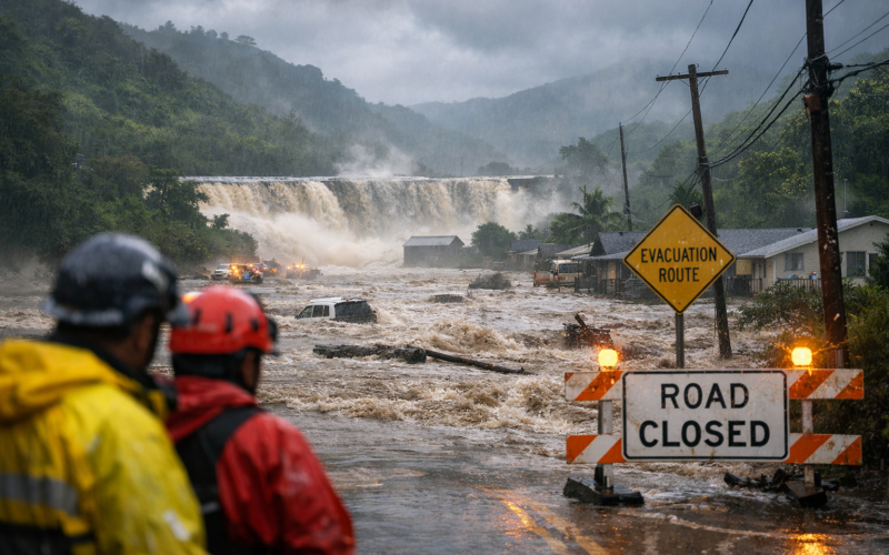
Thousands of residents in towns north of Honolulu, on the island of Oahu in the state of Hawaii, were ordered to evacuate their homes on Friday, March 20, 2026, as catastrophic flooding from a second consecutive Kona low storm system intensified and water levels rose dangerously behind the 120-year-old Wahiawa Dam. The Honolulu Department of Emergency Management issued a mandatory evacuation order at 8:34 a.m. Hawaii Standard Time for all areas downstream of the Wahiawa Dam, warning residents of potential life-threatening flooding and catastrophic amounts of fast-moving water.
The Oahu Department of Emergency Management confirmed that the Wahiawa Dam may collapse or breach at any time. A clarifying bulletin issued at approximately 9:00 a.m. stated that the Wahiawa Dam had not failed but remained at imminent risk of failure, with potential life-threatening flooding of downstream areas. Evacuation orders remained in effect as of midday. The mandatory evacuation zone covered the entirety of Haleiwa between Puuiki Street and Kamehameha Highway, and sections of Waialua between Kukea Circle and Otake Camp.
Molly Pierce, a spokesperson for the Honolulu Department of Emergency Management, confirmed that more than 4,000 people were directly within the evacuation zone, with the broader affected population estimated at approximately 5,500 residents. Emergency sirens were activated along Oahu’s North Shore. Firefighters, airborne crews, and lifeguards operating on jet skis conducted search operations in floodwaters for stranded individuals. Ian Scheuring, a spokesperson for the City and County of Honolulu, confirmed reports of homes being swept away, with the precise number of destroyed structures unable to be determined while floodwaters persisted.
All primary road access into the affected North Shore communities was severed. Kamehameha Highway and Kaukonahua Road, the two main routes into the area, were both inundated. Pierce stated that all points into the area were flooded, both from central Oahu and from the Kahuku North Shore side. The United States Coast Guard deployed boats and aircraft to the Haleiwa area and urged residents to refrain from entering or driving through standing or fast-moving water.
What rainfall totals and weather conditions caused the March 20, 2026 flash flood emergency on Oahu’s North Shore?
The National Weather Service in Honolulu issued a flash flood emergency, the highest-level flood warning classification available, for northern Oahu. The National Weather Service described the event as an ultra-rare flooding occurrence, noting that the previous flash flood emergency issued for the Honolulu area had been more than five years earlier, in March 2021. Parts of northern Oahu received between eight and twelve inches of rain overnight on March 19 into March 20, 2026. Kaala, the highest peak on Oahu, recorded nearly sixteen inches of rainfall in the preceding twenty-four-hour period, compounding the 26.6 inches that had already fallen across that location between March 10 and March 16 during the first Kona low storm of the month.
The National Weather Service characterised the accumulated rainfall as equivalent to two to three months of typical precipitation falling within a single day. The ground across northern Oahu was fully saturated when the second Kona low arrived, causing rainfall to run off immediately into streams, drainage channels, and the Wahiawa Reservoir without the moderating absorption that unsaturated soil normally provides. Kona low storm systems generate southerly or south-westerly winds that carry warm, moisture-laden air against Hawaii’s mountain ranges, producing intense orographic rainfall on slopes and summits. Climate scientists have documented an increase in the intensity and frequency of heavy rainfall events in Hawaii in recent decades, a trend attributed to human-caused global warming and warming ocean temperatures.
Why is the 120-year-old Wahiawa Dam owned by Dole Food Co. Hawaii classified as a high hazard structure?
The Wahiawa Dam, which impounds Lake Wilson on central-northern Oahu, was constructed approximately 120 years ago as part of the plantation-era irrigation infrastructure that supported Hawaii’s sugar cane industry. The dam is currently owned and operated by Dole Food Co. Hawaii. Hawaii state authorities have formally classified the Wahiawa Dam as having high hazard potential, with state assessments concluding that a failure would result in probable loss of human life in the downstream communities of Haleiwa and Waialua. Prior to the second Kona low storm, Dole Food Co. Hawaii had deployed a portable AquaDam barrier to temporarily increase the dam’s height from 88 feet to 90 feet as a precautionary measure. The water level in the Wahiawa Reservoir reached 85.1 feet as of 9:15 a.m. on March 20, 2026, according to the United States Geological Survey.
A Civil Beat investigative report published on March 20, 2026, found that Dole Food Co. had been aware for nearly five decades that the century-old dam structure could cause flooding during heavy rainfall events, yet had undertaken limited maintenance improvements over that period. The state of Hawaii had, according to the same report, repeatedly warned the company about structural safety issues and required significant improvements, the majority of which had not been completed. The state of Hawaii administers 132 dams across the island chain, most of which were constructed during the plantation agriculture era. A 2019 infrastructure assessment by the American Society of Civil Engineers identified the ageing condition of Hawaii’s dam stock as a persistent concern. The Ka Loko Dam collapse on the island of Kauai in 2006, which killed seven people, represents the most recent catastrophic dam failure in Hawaii’s history.
How did federal, state, and county emergency agencies coordinate their response to the Oahu flooding on March 20, 2026?
Hawaii Governor Josh Green activated the Hawaii National Guard and ordered the closure of all state offices before noon on Friday, stating that the action would allow families to focus on reaching safety and would support emergency operations. Governor Green described the situation as one being taken extremely seriously, given the catastrophic flash flooding already impacting Oahu and the active evacuation orders on the North Shore. The Hawaii National Guard conducted airlift operations to evacuate approximately 70 people, including children and elderly residents, from the Our Lady of Keaau retreat on Oahu’s western coast, where floodwaters had severed road access.
The United States Coast Guard deployed watercraft and aircraft to the Haleiwa area to support rescue operations and monitor conditions near the Wahiawa Dam. The Hawaii Department of Transportation issued road closure notifications across Oahu as floodwaters rendered multiple major highways impassable. Electric utility operators shut off power to approximately 4,100 customers on the North Shore at the request of fire officials, with the total island-wide outage figure approaching 9,000 customers by mid-morning. The Hawaiian Electric Companies advised customers across Oahu, Hawaii Island, and Maui County to prepare for possible additional outages as saturated ground and moderate winds raised the risk of trees falling onto power infrastructure.
The City and County of Honolulu established multiple emergency assembly areas across Oahu. George Fred Wright Wahiawa District Park served as a primary assembly point, with additional sites at Kahuku Elementary School and Nanakuli High School. When the Waialua High and Intermediate School shelter was itself inundated by floodwaters, the 185 people and 50 pets sheltering there required transfer to an alternate evacuation facility. The Honolulu Department of Emergency Management acknowledged that the severity of the overnight rainfall had exceeded the forecast prepared earlier in the week and that the emergency had developed faster than anticipated.
During an afternoon press conference, Honolulu Mayor Rick Blangiardi stated that dozens, and possibly hundreds, of homes had been damaged across the North Shore communities. He noted that authorities had not been able to conduct a full damage assessment due to the continuing presence of floodwaters. Mayor Blangiardi expressed confidence in the overall structural stability of Oahu’s dams as conditions began to stabilise at midday, while cautioning that the amount of further rainfall from the continuing storm remained unpredictable and that additional heavy rain bands were still expected to arrive before the end of March 20.
How did the second Kona low storm in one week compound the existing flood damage across northern Oahu in March 2026?
The first Kona low storm system to strike Hawaii in March 2026 arrived during the week of March 10, delivering exceptional rainfall totals across Oahu and causing catastrophic flooding that washed away roads and destroyed homes across the state. A similar but initially forecast to be weaker system was predicted to arrive later in the week, though the actual intensity of the second storm’s overnight rainfall significantly exceeded the projections prepared by the National Weather Service. Pierce described the overnight conditions as having caught the Honolulu Department of Emergency Management by surprise.
The compounding effect of two consecutive storm systems on fully saturated ground produced flooding conditions that were more severe than either storm would have generated in isolation. Historical context provided by longtime North Shore residents reflected the exceptional nature of the flooding. Waialua resident Kathleen Pahinui, while preparing to evacuate to higher ground, described the Wahiawa Dam as a persistent concern during heavy rainfall events. Attorney Denise Antolini, who lives near Pupukea on the North Shore, described road conditions on Kamehameha Highway as the worst she had seen in 35 years of residence in the area.
Key takeaways on what the Oahu dam failure risk and catastrophic flooding means for Hawaii’s communities and infrastructure oversight
- The Honolulu Department of Emergency Management ordered the evacuation of more than 4,000 to 5,500 residents in Haleiwa and Waialua on March 20, 2026, after the Wahiawa Dam was assessed as being at imminent risk of failure following overnight rainfall of eight to twelve inches across northern Oahu, the second major Kona low storm event within a single week.
- The Wahiawa Dam, a 120-year-old structure owned by Dole Food Co. Hawaii and classified by the state of Hawaii as having high hazard potential, had not failed as of midday on March 20, 2026, but remained at imminent risk; an investigative report published on the same day found that the company had been aware of the dam’s flood risk for nearly five decades and had not completed state-mandated improvements.
- The National Weather Service in Honolulu issued a flash flood emergency, the highest available warning classification, describing the event as ultra-rare, with the preceding flash flood emergency for the Honolulu area having occurred more than five years earlier in March 2021.
- Hawaii Governor Josh Green activated the Hawaii National Guard, closed all state offices, and coordinated a multi-agency emergency response involving the United States Coast Guard, the City and County of Honolulu, and the Hawaii Department of Transportation; the National Guard conducted airlift evacuations from at least one community cut off by floodwaters.
- Hawaii’s 132 state-regulated dams, the majority constructed during the plantation agriculture era, face ongoing maintenance challenges; the 2006 Ka Loko Dam collapse on Kauai, which killed seven people, and the March 2026 Wahiawa Dam crisis have intensified scrutiny of dam safety oversight and compliance enforcement across the state.
Discover more from Business-News-Today.com
Subscribe to get the latest posts sent to your email.